IMAGES TAKEN NEAR TO
Woodstock Road, LONDON, W4 1EE
Introduction
This page details the photographs taken nearby to Woodstock Road, W4 1EE by members of the Geograph project.
The Geograph project started in 2005 with the aim of publishing, organising and preserving representative images for every square kilometre of Great Britain, Ireland and the Isle of Man.

There are currently over 7.5m images from over14,400 individuals and you can help contribute to the project by visiting https://www.geograph.org.uk
Image Map
Images are licensed for reuse under creativecommons.org/licenses/by-sa/2.0
Notes
- Clicking on the map will re-center to the selected point.
- The higher the marker number, the further away the image location is from the centre of the postcode.
Image Listing (55 Images Found)
Images are licensed for reuse under creativecommons.org/licenses/by-sa/2.0
Image
Details
Distance
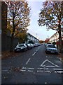
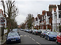
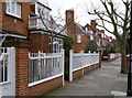
2
Woodstock Road
Part of the later phase of development of the Bedford Park Estate, from around 1890 to 1900.
An oddity of this section of Woodstock Road is that the boundary between Hounslow and Ealing Boroughs runs along the garden front wall, so the houses on the left are not in the same Borough as the street.
Image: © Alan Murray-Rust
Taken: 10 Jan 2012
0.05 miles
3
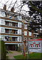
Emlyn Gardens
Late 1930s flats development.
Image: © Alan Murray-Rust
Taken: 10 Jan 2012
0.05 miles
4
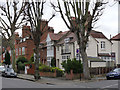
51 Woodstock Road
On the corner of Blandford Road, just outside the original area of development of the estate.
Image: © Alan Murray-Rust
Taken: 10 Jan 2012
0.07 miles
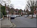
5
Blandford Road
Bedford Park Estate. Looking west from Woodstock Road.
Image: © Alan Murray-Rust
Taken: 10 Jan 2012
0.07 miles
6
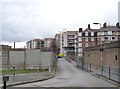
Acton: Former North & South Western Junction Railway
It now appears as an empty curved scar across the map, but when it was first built in 1858 this, the Hammersmith Branch of the North & South Western Junction Railway (NSWJR), was the only main man-made feature in an otherwise rural and agricultural landscape. The NSWJR was originally built to connect the London and North Western Railway at Willesden Junction with the London and South Western Railway at Old Kew Junction. This Hammersmith branch from Acton was never a success, and whatever traffic it was designed to take rapidly disappeared as other railway lines built better connections to the centre of London. The passenger service was withdrawn during the First World War, at the start of 1917, and never reinstated. Freight services lingered on, serving a coal and asphalt depot, until 1965, when the track was lifted.
Today this section of the old route is a secure private car park. For a view in the opposite direction, from a point in the distance, please see Alex's Image
Image: © Nigel Cox
Taken: 25 Sep 2011
0.08 miles
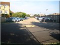
8
The bottom of Warple Way
Emlyn Gardens flats to the right with the Factory Quarter (former C.A.V. site) development behind.
Image: © Alan Murray-Rust
Taken: 10 Jan 2012
0.10 miles
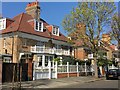
9
Bedford Park railings
At No.56 Woodstock Road, listed Grade II.
Image: © Alan Murray-Rust
Taken: 10 Jan 2012
0.10 miles
10
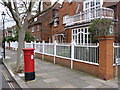
Woodstock Road | Blenheim Road postbox (ref. W4 27)
VR cipher pillar box in Bedford Park Estate.
Image: © Alan Murray-Rust
Taken: 10 Jan 2012
0.10 miles