IMAGES TAKEN NEAR TO
Rectory Road, LONDON, W3 9NR
Introduction
This page details the photographs taken nearby to Rectory Road, W3 9NR by members of the Geograph project.
The Geograph project started in 2005 with the aim of publishing, organising and preserving representative images for every square kilometre of Great Britain, Ireland and the Isle of Man.

There are currently over 7.5m images from over14,400 individuals and you can help contribute to the project by visiting https://www.geograph.org.uk
Image Map
Images are licensed for reuse under creativecommons.org/licenses/by-sa/2.0
Notes
- Clicking on the map will re-center to the selected point.
- The higher the marker number, the further away the image location is from the centre of the postcode.
Image Listing (222 Images Found)
Images are licensed for reuse under creativecommons.org/licenses/by-sa/2.0
Image
Details
Distance
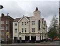
2

The Kings Head, W3
On the corner of King Street and Acton High Street
Image: © Phillip Perry
Taken: 31 Oct 2010
0.04 miles
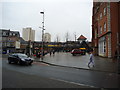
4

Narrow Street
A name to fit the width of the street.
Image: © Alan Murray-Rust
Taken: 10 Jan 2012
0.04 miles
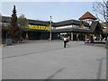
5
Blue Star Hotel
Hotel and Chinese restaurant. Formerly the Blue Anchor.
Image: © Alan Murray-Rust
Taken: 10 Jan 2012
0.04 miles
6
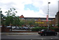
Acton - temple to Mammon
The Morrisons superstore which seems to have eaten much of Acton's central area.
Image: © Peter Whatley
Taken: 6 Apr 2010
0.05 miles