IMAGES TAKEN NEAR TO
Chatsworth Gardens, LONDON, W3 9LP
Introduction
This page details the photographs taken nearby to Chatsworth Gardens, W3 9LP by members of the Geograph project.
The Geograph project started in 2005 with the aim of publishing, organising and preserving representative images for every square kilometre of Great Britain, Ireland and the Isle of Man.

There are currently over 7.5m images from over14,400 individuals and you can help contribute to the project by visiting https://www.geograph.org.uk
Image Map
Images are licensed for reuse under creativecommons.org/licenses/by-sa/2.0
Notes
- Clicking on the map will re-center to the selected point.
- The higher the marker number, the further away the image location is from the centre of the postcode.
Image Listing (165 Images Found)
Images are licensed for reuse under creativecommons.org/licenses/by-sa/2.0
Image
Details
Distance
1
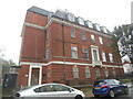
Acton Telephone Exchange (1)
This 1930's redbrick building is situated in Lexden Road W3 9NZ, and is typical of the TEs that were built in Greater London during that time. It has the code LWACT and provides telephone and broadband services to 14,685 residential and 721 non-residential premises in the Acton area. The words TELEPHONE EXCHANGE can be seen above the entrance door to the left of the TE.
Image: © David Hillas
Taken: 12 Oct 2019
0.08 miles
2
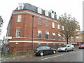
Acton Telephone Exchange (2)
This photo of the TE is taken in Barlow Road W3 9LJ, near the junction with Lexden Road. It used to have ACOrn numbers until the late 1960s, but then had 01-992, 993 xxxx numbers. These were changed to 0208 numbers during the year 2000, and 0208-752,896,992 and 993 xxxx numbers are now provided by this TE. A KX200 telephone kiosk can be seen to the left of the photo, although its payphone has been taken out which probably means that the kiosk itself will be removed before long.
Image: © David Hillas
Taken: 12 Oct 2019
0.08 miles
3
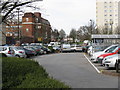
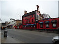
Towards Lexden Road, Acton
Morrisons superstore's car park occupies the foreground.
Image: © Peter Whatley
Taken: 6 Apr 2010
0.10 miles
5
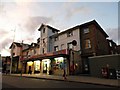
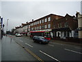
Shops at the end of High Street, Acton
These were derelict for many years and one day returned to normal use like magic, completely unchanged apart from being cleaned up.
Image: © David Howard
Taken: 5 Oct 2013
0.10 miles
8
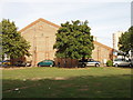
Twyford Sports Centre, Acton
This sports hall with adjacent hard surface sports area are used by Twyford Church of England High School during the day, and as a public sports centre in the evenings and weekends. It is on the site of Farnell's teddy bear factory.
Image: © David Hawgood
Taken: 17 Sep 2006
0.11 miles
9

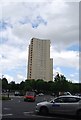
Moreton Tower, Acton
One of a pair of tower blocks close to the centre of Acton.
Image: © Alan Murray-Rust
Taken: 10 Jan 2012
0.11 miles
10
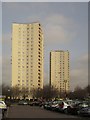
Tower blocks, Acton
Another photo (see also Image) of Rufford Tower and Moreton Tower, seen here from Morrisons' car park. Each block has 100 flats.
Image: © Derek Harper
Taken: 21 Mar 2013
0.11 miles