IMAGES TAKEN NEAR TO
Mayfield Road, LONDON, W3 9HQ
Introduction
This page details the photographs taken nearby to Mayfield Road, W3 9HQ by members of the Geograph project.
The Geograph project started in 2005 with the aim of publishing, organising and preserving representative images for every square kilometre of Great Britain, Ireland and the Isle of Man.

There are currently over 7.5m images from over14,400 individuals and you can help contribute to the project by visiting https://www.geograph.org.uk
Image Map
Images are licensed for reuse under creativecommons.org/licenses/by-sa/2.0
Notes
- Clicking on the map will re-center to the selected point.
- The higher the marker number, the further away the image location is from the centre of the postcode.
Image Listing (39 Images Found)
Images are licensed for reuse under creativecommons.org/licenses/by-sa/2.0
Image
Details
Distance
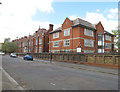
1
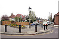
Junction of Creswick Road, Mayfield Road and Lynton Road, Acton, W3
View towards Creswick Road. Note the old lampposts.
Image: © MrC
Taken: 2 Apr 2009
0.01 miles
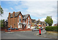
4
Japanese School London, road frontage of grounds
Behind the wall is a running track and playing field. The school has another sports ground north of the main building.
Image: © David Hawgood
Taken: 22 Apr 2015
0.09 miles
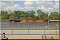
5
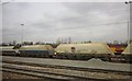
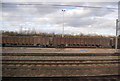
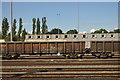
Freight trucks, Acton
With marshalling yards behind; this is between Acton Main Line and Ealing Broadway stations.
Image: © Derek Harper
Taken: 21 Mar 2013
0.09 miles

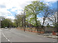
10
Japanese School London, view west along Creffield Road
Image: © David Hawgood
Taken: 22 Apr 2015
0.12 miles