IMAGES TAKEN NEAR TO
Shrublands Lane, W3 9DB
Introduction
This page details the photographs taken nearby to Shrublands Lane, W3 9DB by members of the Geograph project.
The Geograph project started in 2005 with the aim of publishing, organising and preserving representative images for every square kilometre of Great Britain, Ireland and the Isle of Man.

There are currently over 7.5m images from over14,400 individuals and you can help contribute to the project by visiting https://www.geograph.org.uk
Image Map
Images are licensed for reuse under creativecommons.org/licenses/by-sa/2.0
Notes
- Clicking on the map will re-center to the selected point.
- The higher the marker number, the further away the image location is from the centre of the postcode.
Image Listing (235 Images Found)
Images are licensed for reuse under creativecommons.org/licenses/by-sa/2.0
Image
Details
Distance
2
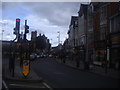
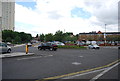
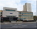
Car park, Acton
Not quite sure why I chose this spot to take a photo of Acton, but it seemed a good idea at the time. As I moved away I discovered a car had been waiting patiently for me to finish - I should think so too!
The car park is that of Morrison's, behind and to the right of the camera. The traffic on the left is at the junction of Steyne Road (right, the A4000) and the High Street, the A4020. On the other side is the Police Station; to the right is the telephone exchange.
Image: © Derek Harper
Taken: 21 Mar 2013
0.02 miles
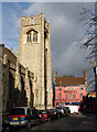
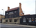
3
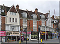
Kings Parade
Retail premises with dwellings over, designed in 1903 by A H Sykes in Art Nouveau style with Arts and Craft influences. The bay windows are in terracotta with some of the first floor panels having decorative plasterwork. Listed Grade II.
Image: © Alan Murray-Rust
Taken: 10 Jan 2012
0.02 miles
4
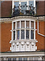
Kings Parade (detail)
One of the terracotta bay windows. Note the fine Art Nouveau handrails to the balcony. Listed Grade II.
Image: © Alan Murray-Rust
Taken: 10 Jan 2012
0.02 miles
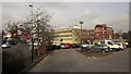
6
Woodlands Avenue
Leading from Woodlands Park to High Street. On the left Acton Hill Methodist Church; straight ahead The Redback public house, formerly The White Hart but now heavily Australianised.
Image: © Alan Murray-Rust
Taken: 10 Jan 2012
0.03 miles
7
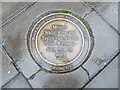
Pavement Plaque in Acton High Street
Located outside 263 Acton High Street W3 9BY, this plaque has the following wording on the inside:
Messrs
Waite, Rose and
Taylor opened the
first Waitrose
shop here in
1904
Around the rim are the names of the bodies Acton History Group and Ealing Civic Society, together with Waitrose Ltd who must have arranged to be plaque to be fitted in the pavement.
Image: © David Hillas
Taken: 12 Oct 2019
0.03 miles
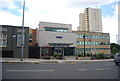
10
The Aeronaut public house, Acton
On High Street, Acton, London W3.
Image: © JThomas
Taken: 13 Apr 2019
0.04 miles