IMAGES TAKEN NEAR TO
Uxbridge Road, LONDON, W3 9BE
Introduction
This page details the photographs taken nearby to Uxbridge Road, W3 9BE by members of the Geograph project.
The Geograph project started in 2005 with the aim of publishing, organising and preserving representative images for every square kilometre of Great Britain, Ireland and the Isle of Man.

There are currently over 7.5m images from over14,400 individuals and you can help contribute to the project by visiting https://www.geograph.org.uk
Image Map
Images are licensed for reuse under creativecommons.org/licenses/by-sa/2.0
Notes
- Clicking on the map will re-center to the selected point.
- The higher the marker number, the further away the image location is from the centre of the postcode.
Image Listing (203 Images Found)
Images are licensed for reuse under creativecommons.org/licenses/by-sa/2.0
Image
Details
Distance
1
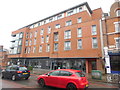
Flats and Gymnasium in Uxbridge Road, Acton
This photo shows the flats and PureGym gymnasium in Acton High Street W3 9QU. They were built on the site of the Acton Tram Depot which originally opened in 1896 for horse-drawn trams, later being used by electric trams and trolleybuses then closing in March 1937. It then reopened as a bus garage in 1990 operating motor buses on route 207 between Shepherd's Bush and Uxbridge, subsequently closing in 2008 then razed to the ground. As the former bus garage had a distinctive appearance, it was perhaps unfortunate that it didn't become a Listed Building, being saved from demolition.
Image: © David Hillas
Taken: 12 Oct 2019
0.01 miles
2
View south along Gunnersbury Lane, W3
Beyond the Red Lion and Pineapple pub (which takes its name from the fact it combines two earlier separate pubs) are new flats built on the site of the old tram depot.
Image: © Christopher Hilton
Taken: 23 Mar 2015
0.02 miles
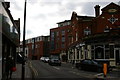
3
Uxbridge Road, Acton
Looking west on the A4020.
Image: © JThomas
Taken: 13 Apr 2019
0.02 miles
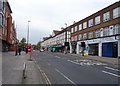
4
Gunnersbury Avenue looking towards High Street Acton
Image: © David Howard
Taken: 10 Sep 2013
0.03 miles
5
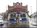
The Red Lion & Pineapple Pub, Acton
Located at 281 Acton High Street W3 9BP, this distinctive building takes its name from two older pubs which were demolished during the construction of Acton Tram Depot nearby. They were replaced on an adjacent site by a new establishment called The Red Lion and Pineapple. It is now a J.D.Wetherspoon pub serving food and drink daily, the Wetherspoon badge being fixed above the red lion. Gunnersbury Lane can just be seen to the left of the pub, whilst Uxbridge Road is to the right.
Image: © David Hillas
Taken: 12 Oct 2019
0.03 miles
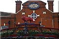
6
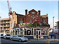
The Red Lion and Pineapple
Wetherspoons pub at the junction of Uxbridge Road and Gunnersbury Lane. The name is not a Wetherspoon's construct. The pub was built as a replacement for two separate pubs, the Red Lion and The Pineapple, when the tramway depot behind was built, and took both names. (The new building behind is on the site of the old tramway depot.)
Image: © Alan Murray-Rust
Taken: 10 Jan 2012
0.03 miles
7

The Red Lion and Pineapple
The fine lion, with pineapple, above the main entrance. See http://www.geograph.org.uk/photo/2766938
Image: © Alan Murray-Rust
Taken: 10 Jan 2012
0.03 miles
9
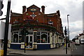
The Red Lion and Pineapple, Acton
The pub gets its name from the fact it combines two earlier pubs, the Red Lion and the Pineapple.
Image: © Christopher Hilton
Taken: 23 Mar 2015
0.03 miles
10
The Red Lion and Pineapple, Acton
The pub gets its name from the fact it combines two earlier pubs, the Red Lion and the Pineapple.
Image: © Christopher Hilton
Taken: 23 Mar 2015
0.03 miles