IMAGES TAKEN NEAR TO
Castle Close, LONDON, W3 8RX
Introduction
This page details the photographs taken nearby to Castle Close, W3 8RX by members of the Geograph project.
The Geograph project started in 2005 with the aim of publishing, organising and preserving representative images for every square kilometre of Great Britain, Ireland and the Isle of Man.

There are currently over 7.5m images from over14,400 individuals and you can help contribute to the project by visiting https://www.geograph.org.uk
Image Map
Images are licensed for reuse under creativecommons.org/licenses/by-sa/2.0
Notes
- Clicking on the map will re-center to the selected point.
- The higher the marker number, the further away the image location is from the centre of the postcode.
Image Listing (73 Images Found)
Images are licensed for reuse under creativecommons.org/licenses/by-sa/2.0
Image
Details
Distance
1
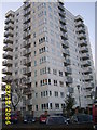
Harlech Tower AKA Nelson Mandela House
This Tower Block was used for the exterior filming in Only Fools And Horses
Image: © Mr M Evison
Taken: 3 Dec 2006
0.06 miles
2
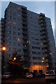
Nelson Mandela House, W3
Ok, it's fiction.
It's actually Harlech Tower in Acton that was used
for the exterior shots for Only Fools and Horses.
Image: © Phillip Perry
Taken: 31 Oct 2010
0.09 miles
3
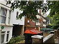
Housing, Avenue Crescent, Acton W3
The building on the left has a green plaque from Ealing Civic Society denoting that William Willett (the originator of daylight saving time) lived at this address 1882-1894.
https://en.wikipedia.org/wiki/William_Willett
Image: © Philip Cornwall
Taken: 4 Oct 2020
0.11 miles
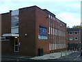
4
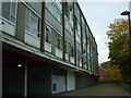
Hardy Court, W3
One of the many dreary and depressing buildings in this part of Acton, part of the South Acton estate.
Image: © Phillip Perry
Taken: 31 Oct 2010
0.15 miles
6
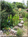
National Garden Scheme, pond in new area of 41 Mill Hill Road
37 and 39 Mill Hill Road next door were redeveloped as 8 flats, it appears that the bottom area of their gardens was added to that of No. 41. The photo shows the pond area. This area of garden is heavily planted with rocks and a gravel surface. See also Image
Image: © David Hawgood
Taken: 3 Sep 2023
0.16 miles
7
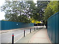
South end of Church Road, Acton
In an area currently being redeveloped, hence the palings on all sides.
Image: © Richard Vince
Taken: 23 Sep 2017
0.16 miles
8
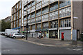
Shops on Hanbury Road
Located on the ground floor level of Buchan House on the South Acton Estate. Most of the 'shops' are now given over to community associations and services. The corner Post Office has closed - its premises now used by SAFE Family Support Service.
Image: © Martin Addison
Taken: 31 Oct 2013
0.17 miles
9
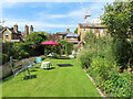
National Garden Scheme, 41 Mill Hill Road, tea on the lawn
The garden was open for charity, and with assistance from neighbours was providing home-made teas. On the left of the photo is a long low lavender hedge, on the right a varied selection of plants. See also Image
Image: © David Hawgood
Taken: 3 Sep 2023
0.17 miles
10
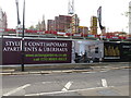
Uberhaus under construction, South Acton
The Daily Telegraph in an article "Duplex apartments: going up in the world" defines Uberhaus as "a name dreamed up by one developer to make its penthouses sound different". So it's a maisonette on the top two floors of a block of flats, with its own internal staircase. This is in South Acton, a large area of council tower blocks now being regenerated, described by the developer as "just minutes from fashionable Chiswick".
Image: © David Hawgood
Taken: 10 May 2014
0.17 miles