IMAGES TAKEN NEAR TO
Princes Avenue, LONDON, W3 8LT
Introduction
This page details the photographs taken nearby to Princes Avenue, W3 8LT by members of the Geograph project.
The Geograph project started in 2005 with the aim of publishing, organising and preserving representative images for every square kilometre of Great Britain, Ireland and the Isle of Man.

There are currently over 7.5m images from over14,400 individuals and you can help contribute to the project by visiting https://www.geograph.org.uk
Image Map
Images are licensed for reuse under creativecommons.org/licenses/by-sa/2.0
Notes
- Clicking on the map will re-center to the selected point.
- The higher the marker number, the further away the image location is from the centre of the postcode.
Image Listing (238 Images Found)
Images are licensed for reuse under creativecommons.org/licenses/by-sa/2.0
Image
Details
Distance
1
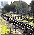
Acton Town tube station
The sidings on the right lead to London Underground's Acton Works.
Image: © Thomas Nugent
Taken: 8 Oct 2014
0.07 miles
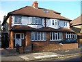
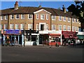
2
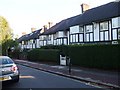
Princes Avenue, W3
A fine example of mock tudor houses built in this area in the 1920's and 30's.
Image: © Phillip Perry
Taken: 25 Sep 2009
0.08 miles
3
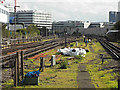
Acton Town tube station
Tracks to the south of the station which is served by the Piccadilly and District Lines.
Image: © Thomas Nugent
Taken: 8 Oct 2014
0.10 miles
4
The entrance to Frank Pick House, South Acton
Frank Pick designed the London Underground map and this is one of their large depots.
Image: © David Howard
Taken: 14 Jun 2020
0.10 miles
5
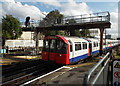
Acton Town tube station
A train approaching Platform 2.
Image: © Thomas Nugent
Taken: 8 Oct 2014
0.12 miles
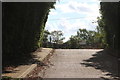
6
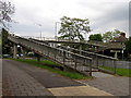
Pedestrian Bridge over the A406 (T)
The bridge is situated just inside the southern edge of the grid square. This picture was taken from the south side of the footbridge, near the side entrance to Gunnersbury Park.
Image: © Pam Brophy
Taken: 10 May 2005
0.13 miles
7
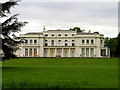
Rothschilds Mansion
One of two mansions in the park. This one was bought by the Rothschilds family and expanded. It is situated in the south west corner of the grid square. This view is from the south side of the building.
Image: © Pam Brophy
Taken: 10 May 2005
0.13 miles
8
5 & 7 Gunnersbury Crescent, Acton, London W3
Image: © Janusz Lukasiak
Taken: 29 Oct 2008
0.13 miles
9
Corner of Bollo Lane and Gunnersbury Lane
Next to Acton Town tube station (London W3). Gunnersbury Lane is on the left, Bollo Lane on the right.
Image: © Janusz Lukasiak
Taken: 29 Oct 2008
0.13 miles
10
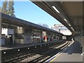
Acton Town tube station
Westbound platform. The station building, on the street level, is the background.
Image: © Janusz Lukasiak
Taken: 29 Oct 2008
0.13 miles