IMAGES TAKEN NEAR TO
The Ridgeway, LONDON, W3 8LN
Introduction
This page details the photographs taken nearby to The Ridgeway, W3 8LN by members of the Geograph project.
The Geograph project started in 2005 with the aim of publishing, organising and preserving representative images for every square kilometre of Great Britain, Ireland and the Isle of Man.

There are currently over 7.5m images from over14,400 individuals and you can help contribute to the project by visiting https://www.geograph.org.uk
Image Map
Images are licensed for reuse under creativecommons.org/licenses/by-sa/2.0
Notes
- Clicking on the map will re-center to the selected point.
- The higher the marker number, the further away the image location is from the centre of the postcode.
Image Listing (310 Images Found)
Images are licensed for reuse under creativecommons.org/licenses/by-sa/2.0
Image
Details
Distance
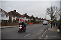
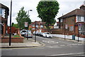
3
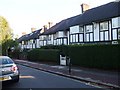
Princes Avenue, W3
A fine example of mock tudor houses built in this area in the 1920's and 30's.
Image: © Phillip Perry
Taken: 25 Sep 2009
0.06 miles
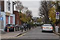
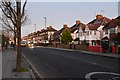
4
Gunnersbury Lane
Gunnersbury Gardens is to the right. The traffic island appears to be fairly new.
Image: © Thomas Nugent
Taken: 26 Sep 2011
0.07 miles
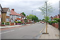
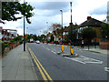
8
Gunnersbury Lane
Looking towards Acton Town tube station.
Image: © Thomas Nugent
Taken: 26 Sep 2011
0.07 miles
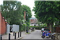
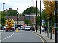
10
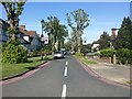
The Ridgeway, Gunnersbury
The huge trees have just been pollarded. They had grown across the road and were taking the light away from the houses.
Image: © David Howard
Taken: 22 May 2017
0.07 miles