IMAGES TAKEN NEAR TO
Mill Hill Road, LONDON, W3 8JJ
Introduction
This page details the photographs taken nearby to Mill Hill Road, W3 8JJ by members of the Geograph project.
The Geograph project started in 2005 with the aim of publishing, organising and preserving representative images for every square kilometre of Great Britain, Ireland and the Isle of Man.

There are currently over 7.5m images from over14,400 individuals and you can help contribute to the project by visiting https://www.geograph.org.uk
Image Map
Images are licensed for reuse under creativecommons.org/licenses/by-sa/2.0
Notes
- Clicking on the map will re-center to the selected point.
- The higher the marker number, the further away the image location is from the centre of the postcode.
Image Listing (205 Images Found)
Images are licensed for reuse under creativecommons.org/licenses/by-sa/2.0
Image
Details
Distance
1

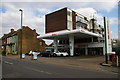
Ex petrol station on Gunnersbury Lane
It has now been converted into shops
Image: © David Howard
Taken: 14 Jun 2020
0.03 miles

3
Flats above former petrol station, Gunnersbury Lane, W3
Image: © Christopher Hilton
Taken: 23 Mar 2015
0.04 miles

5
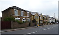
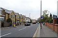
Houses on Gunnersbury Lane, Acton, London W3
Image: © JThomas
Taken: 13 Apr 2019
0.05 miles

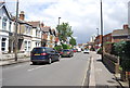
9
Gunnersbury Lane, Acton, London W3
Looking south west on the A4000.
Image: © JThomas
Taken: 13 Apr 2019
0.06 miles
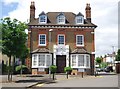
10
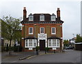
The Passmore Edwards Cottage Hospital, Acton
On Gunnersbury Lane, Acton, London W3.
Image: © JThomas
Taken: 13 Apr 2019
0.06 miles