IMAGES TAKEN NEAR TO
Bollo Lane, W3 8GA
Introduction
This page details the photographs taken nearby to Bollo Lane, W3 8GA by members of the Geograph project.
The Geograph project started in 2005 with the aim of publishing, organising and preserving representative images for every square kilometre of Great Britain, Ireland and the Isle of Man.

There are currently over 7.5m images from over14,400 individuals and you can help contribute to the project by visiting https://www.geograph.org.uk
Image Map
Images are licensed for reuse under creativecommons.org/licenses/by-sa/2.0
Notes
- Clicking on the map will re-center to the selected point.
- The higher the marker number, the further away the image location is from the centre of the postcode.
Image Listing (143 Images Found)
Images are licensed for reuse under creativecommons.org/licenses/by-sa/2.0
Image
Details
Distance
2
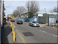
Stirling Road
Industrial premises and a container lorry being loaded on the Rowley Industrial Estate, South Acton.
Image: © Martin Addison
Taken: 31 Oct 2013
0.03 miles
5
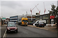
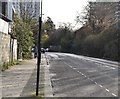
Bollo Lane
Looking towards the level crossing near South Acton station.
Image: © Thomas Nugent
Taken: 9 Oct 2011
0.05 miles
7
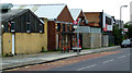
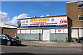
Bollo Lane
Industrial premises typical of the area.
Image: © Thomas Nugent
Taken: 9 Oct 2011
0.06 miles
8
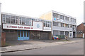
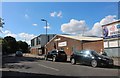
Industrial units in Stirling Road, Acton, W3
Two buildings near to the junction with Roslin Road.
Image: © MrC
Taken: 1 Mar 2009
0.06 miles
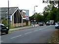
9
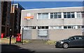
Royal Mail sorting office on Bollo Lane
Image: © David Howard
Taken: 14 Jun 2020
0.07 miles