IMAGES TAKEN NEAR TO
All Saints Road, LONDON, W3 8FG
Introduction
This page details the photographs taken nearby to All Saints Road, W3 8FG by members of the Geograph project.
The Geograph project started in 2005 with the aim of publishing, organising and preserving representative images for every square kilometre of Great Britain, Ireland and the Isle of Man.

There are currently over 7.5m images from over14,400 individuals and you can help contribute to the project by visiting https://www.geograph.org.uk
Image Map
Images are licensed for reuse under creativecommons.org/licenses/by-sa/2.0
Notes
- Clicking on the map will re-center to the selected point.
- The higher the marker number, the further away the image location is from the centre of the postcode.
Image Listing (189 Images Found)
Images are licensed for reuse under creativecommons.org/licenses/by-sa/2.0
Image
Details
Distance
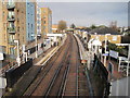
1
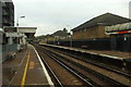
South Acton station
This is where I would normally put W3 or W4, but it's in both.
Part of the old North London Line which is now the London Overground network,
this station was also on the Underground, from Acton Town where a little shuttle service ran until 1959 on the District Line. The station and whole line were closed (again) for engineering works, like almost every Sunday of 2010.
Image: © Phillip Perry
Taken: 31 Oct 2010
0.00 miles
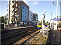
2
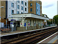
South Acton railway station
The station is on the North London Line, it is operated by London Overground as are all trains which stop here.
Image: © Thomas Nugent
Taken: 9 Oct 2011
0.01 miles
3
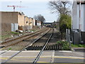
South Acton station from Bollo Lane
Taken from the level crossing on the freight-only line to Brentford.
Image: © Peter Whatley
Taken: 6 Apr 2010
0.01 miles
4
South Acton railway station
The station is on the North London Line, it is operated by London Overground as are all trains which stop here.
Image: © Thomas Nugent
Taken: 9 Oct 2011
0.01 miles
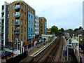
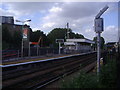
5
South Acton railway station, Greater London
Opened in 1880 by the North & South Western Junction Railway on the line from Willesden to Richmond, this was also formerly a junction for branches to Acton Town and Hammersmith & Chiswick, and 2 bay platforms to left and right were also provided.
View north east towards Acton Central and Willesden, also formerly the short branch to Hammersmith and Chiswick (1858-1917 for passengers) which curved to the right in the distance - the footbridge is wide enough for three tracks.
To the left, where the flats now stand, was the Metropolitan District Railway's station (1905-1959) which had a bay platform at a slightly higher level than the N&SWJR's platforms. For the last 27 years of its life, there was a single-carriage District Line shuttle that ran to and from Acton Town station.
Image: © Nigel Thompson
Taken: 31 Jan 2015
0.01 miles
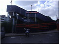
6
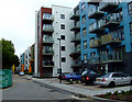
All Saints Road
New flats, close to South Acton overground station.
Image: © Thomas Nugent
Taken: 9 Oct 2011
0.01 miles
10
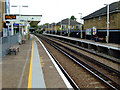
South Acton railway station
The station is on the North London Line, it is operated by London Overground as are all trains which stop here.
Image: © Thomas Nugent
Taken: 9 Oct 2011
0.02 miles