IMAGES TAKEN NEAR TO
Avenue Crescent, LONDON, W3 8ES
Introduction
This page details the photographs taken nearby to Avenue Crescent, W3 8ES by members of the Geograph project.
The Geograph project started in 2005 with the aim of publishing, organising and preserving representative images for every square kilometre of Great Britain, Ireland and the Isle of Man.

There are currently over 7.5m images from over14,400 individuals and you can help contribute to the project by visiting https://www.geograph.org.uk
Image Map
Images are licensed for reuse under creativecommons.org/licenses/by-sa/2.0
Notes
- Clicking on the map will re-center to the selected point.
- The higher the marker number, the further away the image location is from the centre of the postcode.
Image Listing (196 Images Found)
Images are licensed for reuse under creativecommons.org/licenses/by-sa/2.0
Image
Details
Distance
1
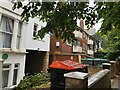
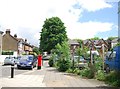
Housing, Avenue Crescent, Acton W3
The building on the left has a green plaque from Ealing Civic Society denoting that William Willett (the originator of daylight saving time) lived at this address 1882-1894.
https://en.wikipedia.org/wiki/William_Willett
Image: © Philip Cornwall
Taken: 4 Oct 2020
0.06 miles
2
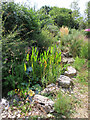
National Garden Scheme, pond in new area of 41 Mill Hill Road
37 and 39 Mill Hill Road next door were redeveloped as 8 flats, it appears that the bottom area of their gardens was added to that of No. 41. The photo shows the pond area. This area of garden is heavily planted with rocks and a gravel surface. See also Image
Image: © David Hawgood
Taken: 3 Sep 2023
0.08 miles
3
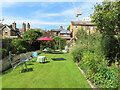
National Garden Scheme, 41 Mill Hill Road, tea on the lawn
The garden was open for charity, and with assistance from neighbours was providing home-made teas. On the left of the photo is a long low lavender hedge, on the right a varied selection of plants. See also Image
Image: © David Hawgood
Taken: 3 Sep 2023
0.09 miles


8
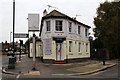
The Mill Hill
Standing on the corner of Mill Hill Road and Gunnersbury Lane this freehouse has sadly closed. There is some structural damage to the building which may be related to the closure.
Image: © Martin Addison
Taken: 31 Oct 2013
0.13 miles

10

The Mill Hill, boarded-up pub on Gunnersbury Lane W3
The Mill Hill had, at the time of this photograph, been boarded up for several years. Building works were now going on.
This whole area of Acton was previously known as Mill Hill, and Acton Town station was originally named Mill Hill Park.
Image: © Christopher Hilton
Taken: 23 Mar 2015
0.13 miles