IMAGES TAKEN NEAR TO
Bollo Bridge Road, LONDON, W3 8AT
Introduction
This page details the photographs taken nearby to Bollo Bridge Road, W3 8AT by members of the Geograph project.
The Geograph project started in 2005 with the aim of publishing, organising and preserving representative images for every square kilometre of Great Britain, Ireland and the Isle of Man.

There are currently over 7.5m images from over14,400 individuals and you can help contribute to the project by visiting https://www.geograph.org.uk
Image Map
Images are licensed for reuse under creativecommons.org/licenses/by-sa/2.0
Notes
- Clicking on the map will re-center to the selected point.
- The higher the marker number, the further away the image location is from the centre of the postcode.
Image Listing (111 Images Found)
Images are licensed for reuse under creativecommons.org/licenses/by-sa/2.0
Image
Details
Distance
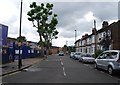
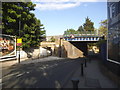
3
Bollo Bridge Road
Modern infill housing between Victorian terraced houses.
Image: © Alan Murray-Rust
Taken: 10 Jan 2012
0.03 miles
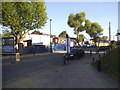
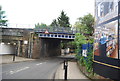
6
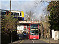
A tight squeeze
Just a few inches clearance for this double deck bus passing under the North London Line bridge on Acton Lane as a train to Richmond passes over the top.
Image: © Alan Murray-Rust
Taken: 10 Jan 2012
0.05 miles
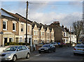
9
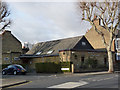
Acton Kingdom Hall
Jehovah's Witnesses' hall on Acton Lane at Leythe Road.
Image: © Alan Murray-Rust
Taken: 10 Jan 2012
0.05 miles
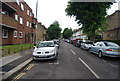
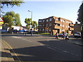
10

Acton Lane at the junction of Petersfield Road
Image: © David Howard
Taken: 16 May 2015
0.06 miles