IMAGES TAKEN NEAR TO
Elizabeth Gardens, LONDON, W3 7SL
Introduction
This page details the photographs taken nearby to Elizabeth Gardens, W3 7SL by members of the Geograph project.
The Geograph project started in 2005 with the aim of publishing, organising and preserving representative images for every square kilometre of Great Britain, Ireland and the Isle of Man.

There are currently over 7.5m images from over14,400 individuals and you can help contribute to the project by visiting https://www.geograph.org.uk
Image Map
Images are licensed for reuse under creativecommons.org/licenses/by-sa/2.0
Notes
- Clicking on the map will re-center to the selected point.
- The higher the marker number, the further away the image location is from the centre of the postcode.
Image Listing (84 Images Found)
Images are licensed for reuse under creativecommons.org/licenses/by-sa/2.0
Image
Details
Distance

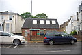
3
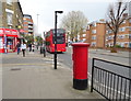
The Vale, Shepherds Bush
Showing position of Postbox No. W3 42.
See Image] for postbox.
Image: © JThomas
Taken: 13 Apr 2019
0.06 miles
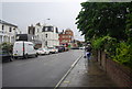
4
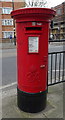
George VI postbox on The Vale, Shepherds Bush
Postbox No. W3 42.
See Image] for context.
Image: © JThomas
Taken: 13 Apr 2019
0.06 miles
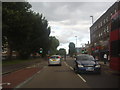
7
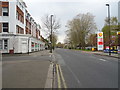
The Vale (A4020)
Looking west at the junction with Cowley Road.
Image: © JThomas
Taken: 13 Apr 2019
0.10 miles
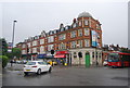
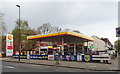
10
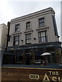
The Askew Pub & Kitchen, Shepherd's Bush, London
On Uxbridge Road.
Image: © JThomas
Taken: 13 Apr 2019
0.12 miles