IMAGES TAKEN NEAR TO
Agnes Road, LONDON, W3 7RE
Introduction
This page details the photographs taken nearby to Agnes Road, W3 7RE by members of the Geograph project.
The Geograph project started in 2005 with the aim of publishing, organising and preserving representative images for every square kilometre of Great Britain, Ireland and the Isle of Man.

There are currently over 7.5m images from over14,400 individuals and you can help contribute to the project by visiting https://www.geograph.org.uk
Image Map
Images are licensed for reuse under creativecommons.org/licenses/by-sa/2.0
Notes
- Clicking on the map will re-center to the selected point.
- The higher the marker number, the further away the image location is from the centre of the postcode.
Image Listing (61 Images Found)
Images are licensed for reuse under creativecommons.org/licenses/by-sa/2.0
Image
Details
Distance
1
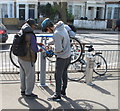
Cyclists use public repair stand
These cyclists were happy to have their photograph taken repairing one of their bikes using the stand and tools provided free. See Image for more details of the stand, which is supplied by Cyclehoops and Fixtation.
Image: © David Hawgood
Taken: 18 Apr 2015
0.06 miles
2
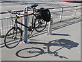
Public bike repair stand, The Vale, Acton
The bicycle is on a stand which has a variety of spanners, screwdrivers and other cycle maintenance tools attached by cables. Behind the bike is a tyre pump. The stand has labels for Cyclehoop and Fixtation. The stand has been installed recently, and does not seem to have any notice on the road announcing its availability.
Image: © David Hawgood
Taken: 18 Apr 2015
0.06 miles
3
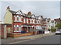
Houses at the corner of Dordrecht Road
Not in the nearby Bedford Park estate, but very much in the same style.
Image: © Alan Murray-Rust
Taken: 10 Jan 2012
0.06 miles
4
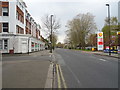
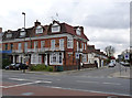
The Vale (A4020)
Looking west at the junction with Cowley Road.
Image: © JThomas
Taken: 13 Apr 2019
0.07 miles
5
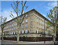
Corner of Bromyard Avenue
The corner of a large residential block along the east side of Bromyard Avenue.
Image: © Des Blenkinsopp
Taken: 13 Apr 2017
0.08 miles
6
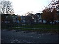
Bromyard Avenue, W3
A semi-circle of land where the local alcoholics meet and drink their tins of cider, and bus route 266 (one of the worst in London for timekeeping) sometimes turn around short of going on to Hammersmith.
Image: © Phillip Perry
Taken: 9 Nov 2008
0.08 miles
8

Beech Avenue Flats
Beech Avenue Flats by The Vale
Image: © Shaun Ferguson
Taken: 3 Mar 2009
0.11 miles