IMAGES TAKEN NEAR TO
The Approach, LONDON, W3 7PS
Introduction
This page details the photographs taken nearby to The Approach, W3 7PS by members of the Geograph project.
The Geograph project started in 2005 with the aim of publishing, organising and preserving representative images for every square kilometre of Great Britain, Ireland and the Isle of Man.

There are currently over 7.5m images from over14,400 individuals and you can help contribute to the project by visiting https://www.geograph.org.uk
Image Map
Images are licensed for reuse under creativecommons.org/licenses/by-sa/2.0
Notes
- Clicking on the map will re-center to the selected point.
- The higher the marker number, the further away the image location is from the centre of the postcode.
Image Listing (91 Images Found)
Images are licensed for reuse under creativecommons.org/licenses/by-sa/2.0
Image
Details
Distance
1
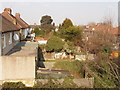
Back gardens of The Approach, North Acton
View north from footbridge over Western Avenue.
Image: © David Hawgood
Taken: 15 Mar 2006
0.01 miles
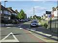
2
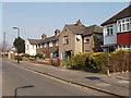
The Approach, North Acton
View north-east across the road, close to Western Avenue.
Image: © David Hawgood
Taken: 15 Mar 2006
0.01 miles
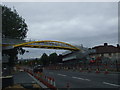
3
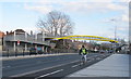
New footbridge over Western Avenue, North Acton
As part of the works to replace two A40 bridges over railway lines, the footbridge over the A40 has been replaced by one with ramps allowing bicycle, pram and wheelchair access. For former footbridge see Image
Image: © David Hawgood
Taken: 4 Apr 2010
0.02 miles
4
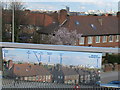
View identification photo on new footbridge, North Acton
The new footbridge shown in Image has a photo showing features in the view. The Trellick Tower in White City is far left in their photo and central in mine. Theirs also shows the BT Tower, London Eye, and Westfield shopping centre and a few others.
Image: © David Hawgood
Taken: 4 Apr 2010
0.02 miles
6
Western Avenue footbridge, W3
Replacing an older bridge due to road widening, bridge strengthening and reconstruction, it isn't fully open yet, but when it is you'll be able to use either ramps or stairs.
Image: © Phillip Perry
Taken: 16 Aug 2009
0.03 miles
7
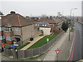
Infill house, corner of The Approach with A40 road
The new-looking lawn and gravel path beside the A40 lead to a building containing 14 and 16 The Approach, fitted in behind 18 The Approach. View from footbridge. 14 and 16 The Approach would have been houses here before Western Avenue was built, and widened to dual carriageway. The name "The Approach" refers to the previous use of the area as a golf course.
Image: © David Hawgood
Taken: 1 Jan 2021
0.03 miles
8
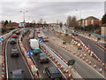
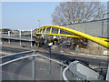
Traffic on temporary bridge during replacement
Two railway bridges on the dual carriageway A40 in Acton are being replaced - see Image for earlier photo and more information. This is Perryn Road bridge, across the London Overground railway. At present there are temporary bridges each for one lane of traffic either side of the original bridge, and pedestrian/cycle bridges hanging outside. The original westbound carriageways have one lane each way at present, the original eastbound carriageways are not in use while the bridge below them is replaced. Lots of traffic cones, and rather confusing for traffic, there is a speed limit. Photo from footbridge.
Image: © David Hawgood
Taken: 3 Feb 2008
0.04 miles
9
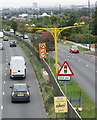
Average speed cameras at roadworks
The yellow post carries CCTV cameras with a numberplate recognition system. This one is at the eastern end of roadworks to replace two bridges, there is another linked one at the western end. The speed limit is usually 40 mph here, reduced to 30 mph through the roadworks. Also in the photo is the sign for the end of the free breakdown recovery which operates through the roadworks. View from footbridge - see Image for an earlier view of the roadworks.
Image: © David Hawgood
Taken: 27 Aug 2008
0.04 miles
10
Footbridge over Western Avenue, the A40
The road opposite is called The Approach.
Image: © Robin Webster
Taken: 27 Mar 2011
0.04 miles