IMAGES TAKEN NEAR TO
The Crescent, LONDON, W3 7PB
Introduction
This page details the photographs taken nearby to The Crescent, W3 7PB by members of the Geograph project.
The Geograph project started in 2005 with the aim of publishing, organising and preserving representative images for every square kilometre of Great Britain, Ireland and the Isle of Man.

There are currently over 7.5m images from over14,400 individuals and you can help contribute to the project by visiting https://www.geograph.org.uk
Image Map
Images are licensed for reuse under creativecommons.org/licenses/by-sa/2.0
Notes
- Clicking on the map will re-center to the selected point.
- The higher the marker number, the further away the image location is from the centre of the postcode.
Image Listing (101 Images Found)
Images are licensed for reuse under creativecommons.org/licenses/by-sa/2.0
Image
Details
Distance
1
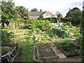
Allotments, The Crescent, East Acton
The allotments are in a small area which is the inside of the crescent.
Image: © David Hawgood
Taken: 18 Sep 2010
0.02 miles
2
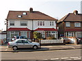
Houses on west side of The Approach, North Acton
View north-west by The Crescent. The houses are just on the edge of the 1 km grid square.
Image: © David Hawgood
Taken: 15 Mar 2006
0.02 miles
3
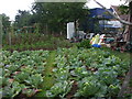
The Crescent, W3
An small allotment in the middle of an estate.
Image: © Phillip Perry
Taken: 16 Aug 2009
0.04 miles
4
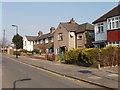
The Approach, North Acton
View north-east across the road, close to Western Avenue.
Image: © David Hawgood
Taken: 15 Mar 2006
0.06 miles
5
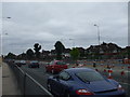
Don't worry, it's nearly finished............
Roadworks on the A40 - Western Avenue replacing two 1930's built railway bridges, and widening that have seemed to have gone on forever, only a few weeks to go.
Image: © Phillip Perry
Taken: 16 Aug 2009
0.07 miles
6
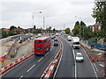
Traffic redirected on temporary bridge
While this railway bridge on the A40 is rebuilt there have to be two lanes available each way. Here the two left hand traffic lanes (with the bus) are on the rebuilt part of the bridge. The two right hand ones are on a temporary bridge. An earlier photo with different traffic flow is Image
Image: © David Hawgood
Taken: 27 Aug 2008
0.07 miles
7
Cotton Avenue eastern branch, North Acton
View north at the junction with Curtis Drive. Modern flats on Westcott Park estate.
Image: © David Hawgood
Taken: 15 Mar 2006
0.07 miles
8
Anderson Close, North Acton
View north from Western Avenue. An estate built recently, mainly flats. It is in a triangle of land between two railway lines and a main road.
Image: © David Hawgood
Taken: 15 Mar 2006
0.08 miles
9
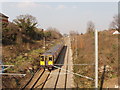
North London line railway from Western Avenue, Acton
View north of train on line from Richmond to Willesden and Hampstead.
Image: © David Hawgood
Taken: 15 Mar 2006
0.08 miles
10
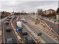
Traffic on temporary bridge during replacement
Two railway bridges on the dual carriageway A40 in Acton are being replaced - see Image for earlier photo and more information. This is Perryn Road bridge, across the London Overground railway. At present there are temporary bridges each for one lane of traffic either side of the original bridge, and pedestrian/cycle bridges hanging outside. The original westbound carriageways have one lane each way at present, the original eastbound carriageways are not in use while the bridge below them is replaced. Lots of traffic cones, and rather confusing for traffic, there is a speed limit. Photo from footbridge.
Image: © David Hawgood
Taken: 3 Feb 2008
0.08 miles