IMAGES TAKEN NEAR TO
Victoria Road, LONDON, W3 6UN
Introduction
This page details the photographs taken nearby to Victoria Road, W3 6UN by members of the Geograph project.
The Geograph project started in 2005 with the aim of publishing, organising and preserving representative images for every square kilometre of Great Britain, Ireland and the Isle of Man.

There are currently over 7.5m images from over14,400 individuals and you can help contribute to the project by visiting https://www.geograph.org.uk
Image Map
Images are licensed for reuse under creativecommons.org/licenses/by-sa/2.0
Notes
- Clicking on the map will re-center to the selected point.
- The higher the marker number, the further away the image location is from the centre of the postcode.
Image Listing (215 Images Found)
Images are licensed for reuse under creativecommons.org/licenses/by-sa/2.0
Image
Details
Distance
1
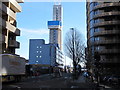
Construction of 24-storey student residence, North Acton
Holbrook House was a branch of NatWest Bank with a few flats above it, total 3 storeys. What is being built on the site of the bank and its car park is a 24-storey tower block for 424 students - see web page of property developer Downing Group https://www.downing.com/plans-for-ealing-student-accommodation-scheme-approved/ or architects SimpsonHaugh and partners https://www.simpsonhaugh.com/projects/holbrook-house .
Image: © David Hawgood
Taken: 12 Feb 2018
0.01 miles
3
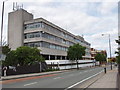
Office block, Park Royal
This is on the west side of Victoria Road, just north of the bridge over the Central Line.
Image: © David Hawgood
Taken: 28 May 2006
0.01 miles
5
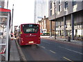
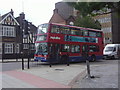
218 bus outside North Acton tube station
Buses from North Acton have just changed. The new 218 service runs between North Acton and Hammersmith via West Acton. The 440 goes along Horn Lane past Acton Main Line station, instead of via West Acton. The 266 runs between Acton Old Town Hall and Brent Cross, avoiding the traffic congestion of Hammersmith to make it more reliable.
Image: © David Hawgood
Taken: 9 Dec 2019
0.02 miles
7
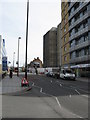
Victoria Road, Acton, looking east
Taken at the exit from North Acton station.
Image: © Peter Whatley
Taken: 6 Apr 2010
0.03 miles
8
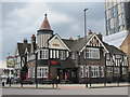
The Castle, Victoria Road / Wales Farm Road, NW10
Image: © Mike Quinn
Taken: 20 Apr 2012
0.03 miles
9

Sign for The Castle, Victoria Road / Wales Farm Road, NW10
See Image
Image: © Mike Quinn
Taken: 20 Apr 2012
0.03 miles
10
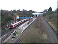
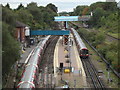
North Acton Underground station
North Acton station is on London Underground's Central Line. It has three platforms. The Underground's tracks are electrified. The separate track to the right of this image is part of the national railway network and is managed by Network Rail. The Underground and Network Rail tracks run alongside each other from North Acton to West Ruislip, a distance of about 8 miles.
Image: © Malc McDonald
Taken: 28 Dec 2012
0.03 miles