IMAGES TAKEN NEAR TO
Rosebank Way, LONDON, W3 6TU
Introduction
This page details the photographs taken nearby to Rosebank Way, W3 6TU by members of the Geograph project.
The Geograph project started in 2005 with the aim of publishing, organising and preserving representative images for every square kilometre of Great Britain, Ireland and the Isle of Man.

There are currently over 7.5m images from over14,400 individuals and you can help contribute to the project by visiting https://www.geograph.org.uk
Image Map
Images are licensed for reuse under creativecommons.org/licenses/by-sa/2.0
Notes
- Clicking on the map will re-center to the selected point.
- The higher the marker number, the further away the image location is from the centre of the postcode.
Image Listing (249 Images Found)
Images are licensed for reuse under creativecommons.org/licenses/by-sa/2.0
Image
Details
Distance
1
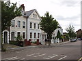
York Road, North Acton
This is taken from the end of the road where it joins Western Avenue
Image: © David Hawgood
Taken: 28 May 2006
0.01 miles
2
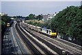
Trains at Acton Main line
A loaded stone train for the East heads slowly up the bank which connects the Western Region main line with the North London line. This provides access to the North, East and South across London. Straight on is the route to Paddington behind the photographer. An HST is seen heading west having left Paddington station about 4 minutes before. Electrification and the Heathrow Express link with the provision of overhead wires has meant this view is not possible now.
Image: © roger geach
Taken: 16 Jul 1994
0.03 miles
3

Digital poster for Personal Protection Equipment (PPE)
A sign of the times at New Year 2021. A year ago few were aware of PPE, now during the coronavirus pandemic its supply is important to all of us. This is along side a main road out of London, A40 Western Avenue. Photo taken on bridge over railway.
Image: © David Hawgood
Taken: 1 Jan 2021
0.05 miles
5
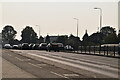
Replacing A40 bridge over Paddington main line railway
The existing bridge taking the dual carriageway A40 over the main railway from Paddington to Reading and the West is 75 years old and needs replacing. The section in the photograph has been built north of the existing bridge, and will be used while the present bridge is replaced. View from pavement on the Northern side of the A40 near Wales Farm Road. See Image for the nearby Perryn Road bridge, also being replaced.
Image: © David Hawgood
Taken: 14 Jan 2007
0.05 miles
6
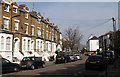
York Road
A quiet side street in North Acton with a fine example of curved terraced housing.
Image: © Martin Addison
Taken: 1 Mar 2012
0.05 miles
7
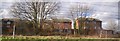
Friary Road, Acton, junction with Western Avenue
View north-east. The main line railway is behind the terrace of houses. The A40 Western Avenue is on the right of the photo, at the end of Friary Road.
Image: © David Hawgood
Taken: 15 Mar 2006
0.06 miles
8
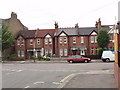
York Road from Rosebank Way, North Acton
Houses on the west side of York Road.
Image: © David Hawgood
Taken: 28 May 2006
0.06 miles
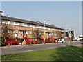
10
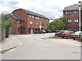
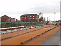
Seacole Close, North Acton
On the site of Leamington Park Hospital, road named after the Crimean War nurse
Image: © David Hawgood
Taken: 2 Aug 2006
0.06 miles