IMAGES TAKEN NEAR TO
Portal Way, LONDON, W3 6RT
Introduction
This page details the photographs taken nearby to Portal Way, W3 6RT by members of the Geograph project.
The Geograph project started in 2005 with the aim of publishing, organising and preserving representative images for every square kilometre of Great Britain, Ireland and the Isle of Man.

There are currently over 7.5m images from over14,400 individuals and you can help contribute to the project by visiting https://www.geograph.org.uk
Image Map
Images are licensed for reuse under creativecommons.org/licenses/by-sa/2.0
Notes
- Clicking on the map will re-center to the selected point.
- The higher the marker number, the further away the image location is from the centre of the postcode.
Image Listing (333 Images Found)
Images are licensed for reuse under creativecommons.org/licenses/by-sa/2.0
Image
Details
Distance
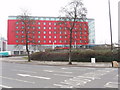
2
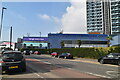
Western Avenue A40 where Olympics traffic will have priority
Photo taken from the first floor of Ramada Encore Hotel by Gypsy Corner while it was being used for consultation about lane closures planned during the 2012 Olympics. The offside lanes of the road in the photo would be used only by Olympics traffic - which will be going to and from Wembley Stadium. Also in the photo is the Shurgard self-store building.
Image: © David Hawgood
Taken: 23 Mar 2011
0.03 miles
3
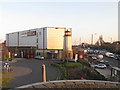
Remploy factory, North Acton
In this factory workers with disabilities make electrical and electronic goods. View across Wales Farm Road. There has been a Remploy factory nearby for many years, with the redevelopment of a large site bounded by Victoria Road and Wales Farm Road the factory has been rebuilt 100 yards from its old site.
Image: © David Hawgood
Taken: 11 Sep 2006
0.03 miles
5
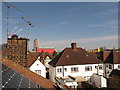
Rooftop view, North Acton, with aerials and cranes
Staying at home during a time of coronavirus the photographer is restricted to new viewpoints, here from a loft window. Solar panels, TV aerial and VHF radio are on this roof. The red building is a Holiday Express hotel at Gypsy Corner; there are planning applications for a 55 storey tower block on the site. Behind it under construction with a crane is a 31-storey student residence for Imperial College on the Perfume Factory site. Seen above the chimney are cranes for the "One West Point" development up to 42 storeys. The foreground 1920s and 1930s houses are in Balfour Road.
Image: © David Hawgood
Taken: 26 Mar 2020
0.05 miles
6
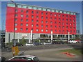
Encore Hotel, Western Avenue W3
From the junction with Horn Lane W3
Image: © Robin Sones
Taken: 19 May 2009
0.06 miles
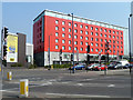
7
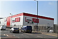
Ramada Encore Hotel, Gipsy Corner, North Acton
The hotel is on the north-east side of Western Avenue. View from the western side of Horn Lane.
Image: © David Hawgood
Taken: 23 Jan 2006
0.06 miles
8
Encore Hotel, 2011
On Western Avenue. This later became a Holiday Inn.
Image: © Robin Webster
Taken: 27 Mar 2011
0.06 miles
9
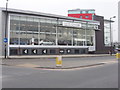
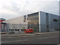
Car showroom, Victoria Road, North Acton
This BMW showroom was at Gipsy Corner, on the corner of Western Avenue. View south-east across Victoria Road towards Western Avenue. (Edit in August 2006 - the showroom has closed).
Image: © David Hawgood
Taken: 23 Jan 2006
0.06 miles
10

Sign for Olympics lane, Gipsy Corner
The A40 Western Avenue is an Olympics route to Wembley Stadium. On days with Olympics football, one lane will be reserved for Olympics traffic where there are 3 lanes available. Temporary digital signs like this will show drivers whether lanes are open or restricted.
Image: © David Hawgood
Taken: 12 Jul 2012
0.07 miles