IMAGES TAKEN NEAR TO
Western Avenue, LONDON, W3 6RN
Introduction
This page details the photographs taken nearby to Western Avenue, W3 6RN by members of the Geograph project.
The Geograph project started in 2005 with the aim of publishing, organising and preserving representative images for every square kilometre of Great Britain, Ireland and the Isle of Man.

There are currently over 7.5m images from over14,400 individuals and you can help contribute to the project by visiting https://www.geograph.org.uk
Image Map
Images are licensed for reuse under creativecommons.org/licenses/by-sa/2.0
Notes
- Clicking on the map will re-center to the selected point.
- The higher the marker number, the further away the image location is from the centre of the postcode.
Image Listing (123 Images Found)
Images are licensed for reuse under creativecommons.org/licenses/by-sa/2.0
Image
Details
Distance
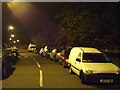
1
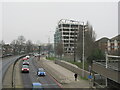
Student residence construction by A40 dual carriageway
At 158-206 Western Avenue Hallmark Property Group is developing a group of co-living student accommodation blocks beside the A40 road, total 599 units. They are shown on the right, with Westcott Estate behind them. On New Year's Day traffic was very light, there is none visible on the left, and a burst of cars on the right released from traffic lights. On a grey misty morning the cars have lights on.
Image: © David Hawgood
Taken: 1 Jan 2021
0.02 miles
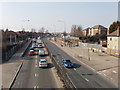
2
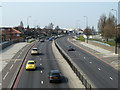
A40 Western Avenue
Looking out of town.
Image: © Robin Webster
Taken: 27 Mar 2011
0.03 miles
3
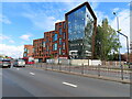
Stay Club, student residence, 200 Western Avenue
The Stay Club website says "this Acton co-living property is aimed at students and young professionals alike". The building is new in 2022.
Image: © David Hawgood
Taken: 29 Aug 2022
0.04 miles
4
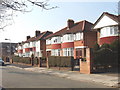
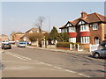
Friary Road, Acton, eastern end
View north-west across the road near the junction with St Dunstan's Avenue. 1930s semi-detached houses.
Image: © David Hawgood
Taken: 15 Mar 2006
0.04 miles
5
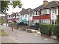
Houses and shared cycle path, Western Avenue, North Acton
These houses are on Western Avenue, the main A40 dual carriageway road with heavy traffic. The pavement is available to cyclists as well as pedestrians.
Image: © David Hawgood
Taken: 16 Sep 2006
0.04 miles
6
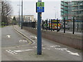
Signs for C34 Cycleway, by St Dunstan's Avenue
Here the westbound cycleway goes onto a service road beside Western Avenue. The link going left is to St Dunstan's Avenue and Friary Road.
Image: © David Hawgood
Taken: 31 Dec 2020
0.04 miles
7
St Dunstan's Avenue, Acton, north end.
View north. The A40 Western Avenue is at the end of the road, but there is no vehicle access. Beyond the A40 are flats in Anderson Close and Cotton Avenue.
Image: © David Hawgood
Taken: 15 Mar 2006
0.06 miles
8
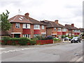
Friars Way, Acton
View from the junction with Friary Road
Image: © David Hawgood
Taken: 20 May 2006
0.06 miles
10
Western Avenue (A40), North Acton
View west from footbridge. The railway bridge seen is over the North London line, Richmond to Willesden Junction and Hampstead. The bridge is being rebuilt. Flats on the right are in Cotton Avenue.
Image: © David Hawgood
Taken: 15 Mar 2006
0.06 miles