IMAGES TAKEN NEAR TO
High Street, LONDON, W3 6QZ
Introduction
This page details the photographs taken nearby to High Street, W3 6QZ by members of the Geograph project.
The Geograph project started in 2005 with the aim of publishing, organising and preserving representative images for every square kilometre of Great Britain, Ireland and the Isle of Man.

There are currently over 7.5m images from over14,400 individuals and you can help contribute to the project by visiting https://www.geograph.org.uk
Image Map
Images are licensed for reuse under creativecommons.org/licenses/by-sa/2.0
Notes
- Clicking on the map will re-center to the selected point.
- The higher the marker number, the further away the image location is from the centre of the postcode.
Image Listing (238 Images Found)
Images are licensed for reuse under creativecommons.org/licenses/by-sa/2.0
Image
Details
Distance
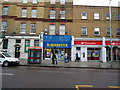
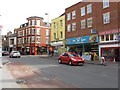
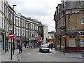
2
Acton High Street - Church Road junction
Image: © Peter Whatley
Taken: 6 Apr 2010
0.02 miles
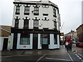
6
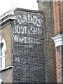
Dadds Boot and Shoe Warehouse
Surviving painted advert on a shop on Acton High Street. See http://www.geograph.org.uk/photo/2767330
Image: © Alan Murray-Rust
Taken: 10 Jan 2012
0.03 miles
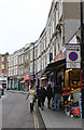
7
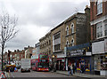
Acton High Street
The interpolated modernist facade in the terrace probably represents replacement for bomb damage. Note the painted advert still showing on the end wall. See http://www.geograph.org.uk/photo/2767327
Image: © Alan Murray-Rust
Taken: 10 Jan 2012
0.03 miles
8
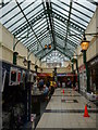
The Oaks Shopping Centre, Acton High Street W3
Image: © Robin Sones
Taken: 31 Jul 2013
0.03 miles
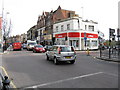
9
Market Place, Acton
The Sheepwalk pub on the right was originally the William IV.
Image: © Alan Murray-Rust
Taken: 10 Jan 2012
0.03 miles
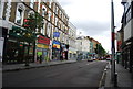
10
Market Place, Acton
A curving side street connecting High Street with Churchfield Road.
Image: © Martin Addison
Taken: 31 Oct 2013
0.03 miles