IMAGES TAKEN NEAR TO
St. Dunstans Avenue, LONDON, W3 6QD
Introduction
This page details the photographs taken nearby to St. Dunstans Avenue, W3 6QD by members of the Geograph project.
The Geograph project started in 2005 with the aim of publishing, organising and preserving representative images for every square kilometre of Great Britain, Ireland and the Isle of Man.

There are currently over 7.5m images from over14,400 individuals and you can help contribute to the project by visiting https://www.geograph.org.uk
Image Map
Images are licensed for reuse under creativecommons.org/licenses/by-sa/2.0
Notes
- Clicking on the map will re-center to the selected point.
- The higher the marker number, the further away the image location is from the centre of the postcode.
Image Listing (42 Images Found)
Images are licensed for reuse under creativecommons.org/licenses/by-sa/2.0
Image
Details
Distance
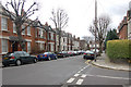
1
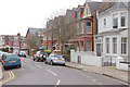
Baldwyn Gardens, Acton, W3
An early Edwardian development.
Image: © MrC
Taken: 26 Feb 2009
0.08 miles
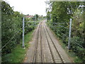
2
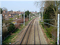
North London Line
Looking north. The overhead wires extend as far south as Acton Central, where electric trains are obliged to switch to third rail.
Image: © Robin Webster
Taken: 27 Mar 2011
0.08 miles
3
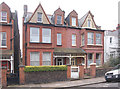
Victorian houses in Baldwyn Gardens, Acton, W3
These houses were completed c.1900.
Image: © MrC
Taken: 26 Feb 2009
0.08 miles
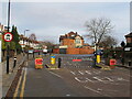
5

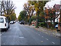
Acton Low Traffic Neighbourhood, Crane Avenue closure
The area behind the photographer is open to traffic from Horn Lane and Western Avenue, that in front from Horn Lane only.
Image: © David Hawgood
Taken: 18 Jan 2021
0.11 miles
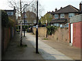
6
Acton: North London Line
This view was taken from the footbridge between Perryn Road and Shakespeare Road, and is looking in the opposite direction from Image The houses to the left are on St Dunstan's Avenue.
Image: © Nigel Cox
Taken: 13 Oct 2010
0.11 miles
7
Junction of Grafton Road and Baldwyn Gardens, Acton, W3
View facing Grafton Road.
Image: © MrC
Taken: 3 Mar 2009
0.13 miles
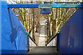
8
Path to Goldsmith Avenue
A link from Perryn Road via a footbridge over the railway.
Image: © Robin Webster
Taken: 27 Mar 2011
0.14 miles
9
Down the steps to Perryn Road
The footbridge over the railway carries the footpath connecting Perryn Road with Goldsmith Avenue.
Image: © Robin Webster
Taken: 27 Mar 2011
0.15 miles
10
Acton Low Traffic Neighbourhood, Goldsmith Avenue closure
The area behind the photographer is accessible from Churchfield Road, that in front from Western Avenue and Horn Lane.
Image: © David Hawgood
Taken: 18 Jan 2021
0.15 miles