IMAGES TAKEN NEAR TO
Western Avenue, LONDON, W3 6ED
Introduction
This page details the photographs taken nearby to Western Avenue, W3 6ED by members of the Geograph project.
The Geograph project started in 2005 with the aim of publishing, organising and preserving representative images for every square kilometre of Great Britain, Ireland and the Isle of Man.

There are currently over 7.5m images from over14,400 individuals and you can help contribute to the project by visiting https://www.geograph.org.uk
Image Map
Images are licensed for reuse under creativecommons.org/licenses/by-sa/2.0
Notes
- Clicking on the map will re-center to the selected point.
- The higher the marker number, the further away the image location is from the centre of the postcode.
Image Listing (165 Images Found)
Images are licensed for reuse under creativecommons.org/licenses/by-sa/2.0
Image
Details
Distance
1
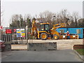
Bridge works, Vardon Close, North Acton
The bridge carrying A40 Western Avenue over the main line railway from Paddington to the west is being rebuilt. part of the construction site is seen here looking north-west from Cotton Avenue to Vardon Close.
Image: © David Hawgood
Taken: 15 Mar 2006
0.02 miles
2
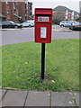
Pole mounted post box, Westcott Estate
The box has the crown and EiiR cypher on a plate stuck on below the letter slot. The words "Royal Mail" are crudely stamped into a strip riveted above the slot. Collection is shown as 9.00 am Monday to Friday, and Saturday. The notice showing this doesn't quite fit the box, so some lettering is obscured. There is a slot for a plate to show the next collection day, but no plate has been installed. Altogether a shoddy effort.
Image: © David Hawgood
Taken: 1 Jan 2021
0.02 miles
4
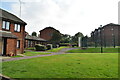
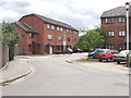
Cotton Avenue
Housing on a modern estate beside the Western Avenue.
Image: © Martin Addison
Taken: 1 Mar 2012
0.04 miles
5
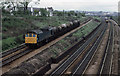
Milk at Acton
Class 25, 25175, descends from Acton Wells Junction towards the Great Western mainline with a train of 6 wheeled milk tankers returning empty to the West Country. This is a type of traffic that is no longer handled by the railways - now exclusively carried by road tankers. Behind the train on the left is part of Leamington Park Hospital. The hospital opened in 1905 as Acton Isolation Hospital and closed in 1983. It was replaced by a housing estate.
Image: © Martin Addison
Taken: Unknown
0.04 miles
6
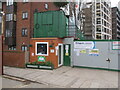
Security hut, construction of co-living apartments
At 158-206 Western Avenue Hallmark Property Group is developing a group of student accommodation blocks beside the A40 road, total 599 units. The alley on the left leads into Westcott Estate.
Image: © David Hawgood
Taken: 1 Jan 2021
0.05 miles
7
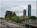
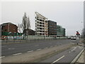
Stay Club and One West Point, Acton
The block on the left next to the Western Avenue dual carriageway is the Stay Club, co-living apartments for students and young professionals. On the right is One West Point, the taller a 54-storey residential tower, between Victoria Road and Portal Way. Photo from footbridge.
Image: © David Hawgood
Taken: 29 Aug 2022
0.05 miles
8
Perry Avenue and main line railway, Westcott Park, Acton
View north-east, with the main railway line to Paddington on the left.
Image: © David Hawgood
Taken: 15 Mar 2006
0.05 miles
9
Construction of co-living blocks, 158-206 Western Avenue
At 158-206 Western Avenue Hallmark Property Group is developing a group of student accommodation blocks beside the A40 road, total 599 units. The near block with white beams and sloping roof is the 206 Western Avenue end. Buildings far left are in Westcott Estate. On the right of the photo the C34 Cycleway continues to East Acton, and links into Friary Road.
Image: © David Hawgood
Taken: 31 Dec 2020
0.06 miles
10
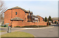
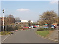
Seacole Close, North Acton
On the site of Leamington Park Hospital, road named after the Crimean War nurse
Image: © David Hawgood
Taken: 2 Aug 2006
0.06 miles