IMAGES TAKEN NEAR TO
Spencer Road, LONDON, W3 6DW
Introduction
This page details the photographs taken nearby to Spencer Road, W3 6DW by members of the Geograph project.
The Geograph project started in 2005 with the aim of publishing, organising and preserving representative images for every square kilometre of Great Britain, Ireland and the Isle of Man.

There are currently over 7.5m images from over14,400 individuals and you can help contribute to the project by visiting https://www.geograph.org.uk
Image Map
Images are licensed for reuse under creativecommons.org/licenses/by-sa/2.0
Notes
- Clicking on the map will re-center to the selected point.
- The higher the marker number, the further away the image location is from the centre of the postcode.
Image Listing (198 Images Found)
Images are licensed for reuse under creativecommons.org/licenses/by-sa/2.0
Image
Details
Distance
1
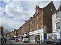
Churchfield Road, Acton
This doesn't look to have changed a lot. Local shops and businesses with housing above.
Image: © Des Blenkinsopp
Taken: 13 Apr 2017
0.09 miles
2
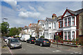
Summerlands Avenue, Acton
Housing of a similar age and style is found all over this area.
Image: © Des Blenkinsopp
Taken: 13 Apr 2017
0.10 miles
3
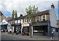
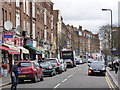
Businesses on Churchfield Road
Churchfield Road is very much an off-the-High-Street shopping street. Not wall to wall clothes and shoes from the usual suspects, but a selection of varied small shops and businesses offering all kinds of things.
Here we have a wine bar, Greek restaurant, hairdressers and a car repair workshop all side by side.
Image: © Des Blenkinsopp
Taken: 13 Apr 2017
0.12 miles
5
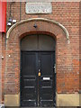
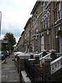
Door and street sign, Derwentwater Road W3
Image: © Robin Sones
Taken: 31 Jul 2013
0.14 miles
6
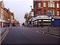
Churchfield Road
Secondary shopping street off Acton Town Centre.
Image: © Alan Murray-Rust
Taken: 10 Jan 2012
0.14 miles

9
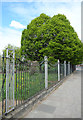
Park Railings, Springfield Gardens
This is the park boundary beside Horn Lane. The Gardens were opened in 1934 and these period railings are lucky to have survived the WW2 scrap metal raids that came a few years later.
Image: © Des Blenkinsopp
Taken: 13 Apr 2017
0.16 miles
10

Building on Horn Lane
This odd looking building was apparently used as a warehouse by the haulage contractor Carter Patterson, later becoming F Hawkins & Co wholesale grocers, who gave their name to the later Hawkco House alongside. Source: http://www.actonhistory.co.uk/acton/page1.html (by email)
Image: © Alan Murray-Rust
Taken: 10 Jan 2012
0.16 miles