IMAGES TAKEN NEAR TO
Burlington Mews, LONDON, W3 6AZ
Introduction
This page details the photographs taken nearby to Burlington Mews, W3 6AZ by members of the Geograph project.
The Geograph project started in 2005 with the aim of publishing, organising and preserving representative images for every square kilometre of Great Britain, Ireland and the Isle of Man.

There are currently over 7.5m images from over14,400 individuals and you can help contribute to the project by visiting https://www.geograph.org.uk
Image Map
Images are licensed for reuse under creativecommons.org/licenses/by-sa/2.0
Notes
- Clicking on the map will re-center to the selected point.
- The higher the marker number, the further away the image location is from the centre of the postcode.
Image Listing (167 Images Found)
Images are licensed for reuse under creativecommons.org/licenses/by-sa/2.0
Image
Details
Distance
1
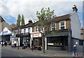
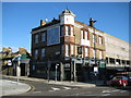
Businesses on Churchfield Road
Churchfield Road is very much an off-the-High-Street shopping street. Not wall to wall clothes and shoes from the usual suspects, but a selection of varied small shops and businesses offering all kinds of things.
Here we have a wine bar, Greek restaurant, hairdressers and a car repair workshop all side by side.
Image: © Des Blenkinsopp
Taken: 13 Apr 2017
0.03 miles
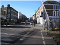
3
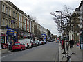
Churchfield Road
Looking towards Acton town centre from near Acton Central Station.
Image: © Alan Murray-Rust
Taken: 10 Jan 2012
0.06 miles
4
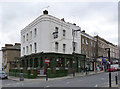
The Rocket, Churchfield Road
Formerly the Station Hotel, the modern name is at least responsive to the old.
Image: © Alan Murray-Rust
Taken: 10 Jan 2012
0.07 miles
5
Acton: The Windmill
A late Victorian pub on the High Street at the junction with Grove Road, the tablet on the High Street frontage to the right has the date 1899.
Image: © Nigel Cox
Taken: 10 Nov 2010
0.09 miles
6
Acton: Churchfields Road
Looking east from the railway level crossing
Image: © Dr Neil Clifton
Taken: 18 Feb 2015
0.09 miles
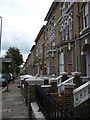
7
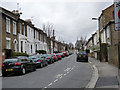
Grove Road
Victorian terraced properties off Acton High Street.
Image: © Alan Murray-Rust
Taken: 10 Jan 2012
0.10 miles
9

Milton Road
Late Victorian terraces to the east of Acton town centre.
Image: © Alan Murray-Rust
Taken: 10 Jan 2012
0.10 miles
10
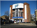
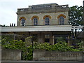
Acton: Gala Bingo Club
Built as the Dominion Cinema in 1937 and closing as the Granada Cinema in 1972 this is now the Gala Bingo Club on Acton's High Street. It is a Grade II Listed Building by virtue of being a good example of a 1930s super-cinema, its facade, and a unique (to cinemas at least) space saving stairway in the foyer. It was designed by Frank Ernest Bromige LRIBA (1902-1979).
The English Heritage Listed Building website describes the exterior as follows:-
"Tall, symmetrical, Moderne facade. In the centre, three sets of paired entrance doors, flanked by splay walls, the first part rendered. In the centre, the first and second floors break forward as a cantilevered structure to form a large area of glazing, at the same time creating a canopy over the entrance. Twin vertical members rise from this canopy to the third floor level, then curve inwards as fins to support an oversized cornice. The vertical members are filled with continuous glazing, which, at first floor level only, bends around on either side to meet the brick. These glazed areas have broad cornices above which are balconies with Art Deco metal balustrades. All glazing with multiple transoms and margin mullions. French doors give on to these balconies either side. At the top is a deep parapet which formerly carried the name of the cinema. This and the top of the fins are masked by a recent metal fascia. The tall slender windows on the flanking stair towers have also been covered."
Image: © Nigel Cox
Taken: 10 Nov 2010
0.11 miles