IMAGES TAKEN NEAR TO
Grove Place, LONDON, W3 6AS
Introduction
This page details the photographs taken nearby to Grove Place, W3 6AS by members of the Geograph project.
The Geograph project started in 2005 with the aim of publishing, organising and preserving representative images for every square kilometre of Great Britain, Ireland and the Isle of Man.

There are currently over 7.5m images from over14,400 individuals and you can help contribute to the project by visiting https://www.geograph.org.uk
Image Map
Images are licensed for reuse under creativecommons.org/licenses/by-sa/2.0
Notes
- Clicking on the map will re-center to the selected point.
- The higher the marker number, the further away the image location is from the centre of the postcode.
Image Listing (243 Images Found)
Images are licensed for reuse under creativecommons.org/licenses/by-sa/2.0
Image
Details
Distance
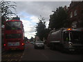
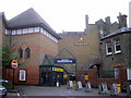
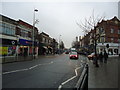
1
Churchfield Road, Acton
This doesn't look to have changed a lot. Local shops and businesses with housing above.
Image: © Des Blenkinsopp
Taken: 13 Apr 2017
0.05 miles
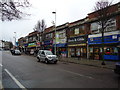
5
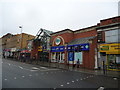
Entrance to Morrisons Supermarket, Acton
Image: © PAUL FARMER
Taken: 11 Jun 2011
0.08 miles
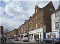
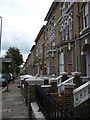
6
Grove Road
Victorian terraced properties off Acton High Street.
Image: © Alan Murray-Rust
Taken: 10 Jan 2012
0.08 miles
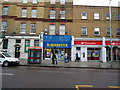
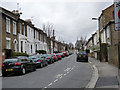
8
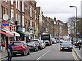
Churchfield Road
Secondary shopping street off Acton Town Centre.
Image: © Alan Murray-Rust
Taken: 10 Jan 2012
0.08 miles