IMAGES TAKEN NEAR TO
Kendal Avenue, LONDON, W3 0RY
Introduction
This page details the photographs taken nearby to Kendal Avenue, W3 0RY by members of the Geograph project.
The Geograph project started in 2005 with the aim of publishing, organising and preserving representative images for every square kilometre of Great Britain, Ireland and the Isle of Man.

There are currently over 7.5m images from over14,400 individuals and you can help contribute to the project by visiting https://www.geograph.org.uk
Image Map
Images are licensed for reuse under creativecommons.org/licenses/by-sa/2.0
Notes
- Clicking on the map will re-center to the selected point.
- The higher the marker number, the further away the image location is from the centre of the postcode.
Image Listing (53 Images Found)
Images are licensed for reuse under creativecommons.org/licenses/by-sa/2.0
Image
Details
Distance
1
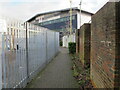
Alley from West Acton tube, exit to Kendal Avenue
This end runs behind warehouses in an industrial estate. The West Acton end is shown in Image
Image: © David Hawgood
Taken: 19 Jan 2021
0.09 miles
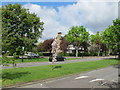
2
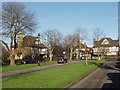
Princes Gardens, West Acton
This is an area of "mock tudor" houses and apartments.
Image: © David Hawgood
Taken: 19 Jan 2007
0.10 miles
3
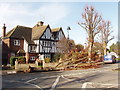
Tree felled by storm, West Acton
Storms on Thursday 18th January were the most damaging for 16 years, and many trees were blown down. This one is in Princes Gardens. Image shows the tree being cleared an hour or so later.
Image: © David Hawgood
Taken: 19 Jan 2007
0.11 miles
4
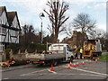
Clearing storm-felled tree, West Acton
Tree felled in storms the day before. Image taken an hour or so before shows the tree before clearance.
Image: © David Hawgood
Taken: 19 Jan 2007
0.11 miles
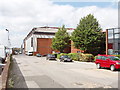
5
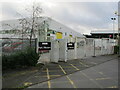
BBC Park Western, Kendal Avenue Acton
According to Wikipedia in January 2021, this is "Production facility for Silent Witness. Home of BBC Newsgathering Operations, responsible for outside broadcasts for BBC News."
Image: © David Hawgood
Taken: 19 Jan 2021
0.11 miles
6
Grass and trees in Prince's Drive
Prince's Drive is a dual carriageway with a centre strip which is grass here, has trees and shrubs in another section. The tree on the left of the photo is a horse chestnut with red flowers; the pink blossom on the centre strip is on a young cherry tree.
Image: © David Hawgood
Taken: 30 Apr 2010
0.15 miles
7
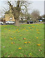
Crocuses on traffic island, Hanger Hill Garden Estate
This grassy island is off Princes Gardens.
Image: © David Hawgood
Taken: 21 Feb 2021
0.15 miles
8
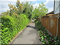
Masons Green Lane
What is now a footpath and cycle track between a railway and housing estate was a lane before those existed. It is shown on the 1870 Ordnance Survey map running between fields. It ran on south through an area which became an airfield, then became Hanger Hill Garden Estate.
Image: © David Hawgood
Taken: 30 Apr 2010
0.15 miles
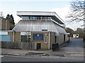
9
Film studio, Alliance Road, North Acton
The large building was a cold store until about 1980. This area has light industry, distribution depots, and warehouse style retail units.
Image: © David Hawgood
Taken: 17 Jun 2005
0.17 miles
10
Roman Catholic Church of the Holy Family, North Ealing
This church in the Diocese of Westminster is in Hanger Vale Lane, in the Hanger Hill Garden Estate Conservation Area.
Image: © David Hawgood
Taken: 4 Apr 2010
0.17 miles