IMAGES TAKEN NEAR TO
Kendal Avenue, LONDON, W3 0RU
Introduction
This page details the photographs taken nearby to Kendal Avenue, W3 0RU by members of the Geograph project.
The Geograph project started in 2005 with the aim of publishing, organising and preserving representative images for every square kilometre of Great Britain, Ireland and the Isle of Man.

There are currently over 7.5m images from over14,400 individuals and you can help contribute to the project by visiting https://www.geograph.org.uk
Image Map
Images are licensed for reuse under creativecommons.org/licenses/by-sa/2.0
Notes
- Clicking on the map will re-center to the selected point.
- The higher the marker number, the further away the image location is from the centre of the postcode.
Image Listing (47 Images Found)
Images are licensed for reuse under creativecommons.org/licenses/by-sa/2.0
Image
Details
Distance
1
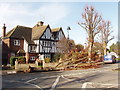
Tree felled by storm, West Acton
Storms on Thursday 18th January were the most damaging for 16 years, and many trees were blown down. This one is in Princes Gardens. Image shows the tree being cleared an hour or so later.
Image: © David Hawgood
Taken: 19 Jan 2007
0.11 miles
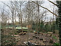
2
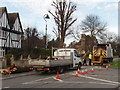
Clearing storm-felled tree, West Acton
Tree felled in storms the day before. Image taken an hour or so before shows the tree before clearance.
Image: © David Hawgood
Taken: 19 Jan 2007
0.11 miles
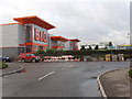
3

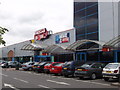
Retail park off the A40, 1996
The names have changed since but not the buildings
Image: © David Howard
Taken: Unknown
0.12 miles
4
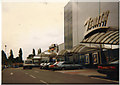
Royale Leisure Park, Park Royal, Acton
This site has a multiplex cinema, discos, bowling, restaurants, bars - all away from any town centre
Image: © David Hawgood
Taken: 5 Jun 2005
0.13 miles
6
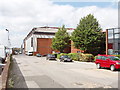
Film studio, Alliance Road, North Acton
The large building was a cold store until about 1980. This area has light industry, distribution depots, and warehouse style retail units.
Image: © David Hawgood
Taken: 17 Jun 2005
0.16 miles
7
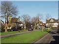
Princes Gardens, West Acton
This is an area of "mock tudor" houses and apartments.
Image: © David Hawgood
Taken: 19 Jan 2007
0.16 miles
8
Retail warehouses, Western Avenue, Acton
On the left a do-it-yourself shop and an office supplies shop. These have been rebuilt about a year ago, replacing a similar building about 20 years old. Beyond, a car showroom and the UK headquarters of Renault.
Image: © David Hawgood
Taken: 20 Jan 2007
0.17 miles
9
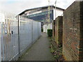
Alley from West Acton tube, exit to Kendal Avenue
This end runs behind warehouses in an industrial estate. The West Acton end is shown in Image
Image: © David Hawgood
Taken: 19 Jan 2021
0.17 miles
10
School environmental garden, Hanger Vale, Ealing
Holy Family Catholic primary school has grounds in a triangle, long sides a tube line and Masons Green Lane. This is the view from the tip of the triangle down to the playground and school. This area has been preserved as if it was a wild area.
Image: © David Hawgood
Taken: 21 Feb 2021
0.18 miles