IMAGES TAKEN NEAR TO
Court Way, LONDON, W3 0PZ
Introduction
This page details the photographs taken nearby to Court Way, W3 0PZ by members of the Geograph project.
The Geograph project started in 2005 with the aim of publishing, organising and preserving representative images for every square kilometre of Great Britain, Ireland and the Isle of Man.

There are currently over 7.5m images from over14,400 individuals and you can help contribute to the project by visiting https://www.geograph.org.uk
Image Map
Images are licensed for reuse under creativecommons.org/licenses/by-sa/2.0
Notes
- Clicking on the map will re-center to the selected point.
- The higher the marker number, the further away the image location is from the centre of the postcode.
Image Listing (257 Images Found)
Images are licensed for reuse under creativecommons.org/licenses/by-sa/2.0
Image
Details
Distance
1
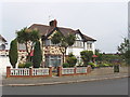
Allan way, North Acton
One house has large cabbage trees in its garden.
Image: © David Hawgood
Taken: 18 Jun 2006
0.01 miles
2
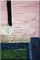
Benchmark on #33 Allan Way
Ordnance Survey cut mark benchmark described on the Bench Mark Database at http://www.bench-marks.org.uk/bm46938
Image: © Roger Templeman
Taken: 26 Jan 2013
0.03 miles
3
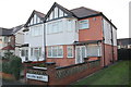
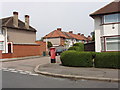
Semi-detached houses on Allan Way
There is an OS benchmark Image on the side of the right hand house, at the junction with the front porch extension
Image: © Roger Templeman
Taken: 26 Jan 2013
0.03 miles
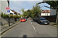
6
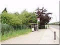
Bus stop on Western Avenue, North Acton
There used to be houses along this road, but they were knocked down to make way for an overpass . . which was then abandoned.
Image: © David Hawgood
Taken: 18 Jun 2006
0.05 miles
7
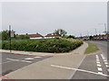
Empty site on Western Avenue, North Acton
This is the end of Court Way where it joins the A40 Western Avenue. Houses along here were demolished for a road scheme, which was abandoned. The site has been fenced, with shrubs planted in front of the fence.
Image: © David Hawgood
Taken: 18 Jun 2006
0.06 miles
8
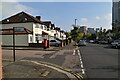
Wilfrid Gardens and Allan Way, North Acton
Photo looking along Wilfrid Gardens from Allan Way. There is a red post box at the corner of the road.
Image: © David Hawgood
Taken: 18 Jun 2006
0.07 miles
9
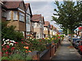
Cloister Road, North Acton
Houses here were built around 1930. Flowers in the gardens are mainly roses, which do well on this clay soil.
Image: © David Hawgood
Taken: 17 Jun 2005
0.07 miles
10
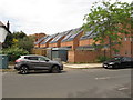
Solar panels, Grieg Road, North Acton
View from Allan Way. Grieg Road is part of the Aviator Place development. Solar panels are being installed on many of the houses in this development as they are built.
Image: © David Hawgood
Taken: 1 Jun 2019
0.07 miles