IMAGES TAKEN NEAR TO
Kathleen Avenue, LONDON, W3 0NG
Introduction
This page details the photographs taken nearby to Kathleen Avenue, W3 0NG by members of the Geograph project.
The Geograph project started in 2005 with the aim of publishing, organising and preserving representative images for every square kilometre of Great Britain, Ireland and the Isle of Man.

There are currently over 7.5m images from over14,400 individuals and you can help contribute to the project by visiting https://www.geograph.org.uk
Image Map
Images are licensed for reuse under creativecommons.org/licenses/by-sa/2.0
Notes
- Clicking on the map will re-center to the selected point.
- The higher the marker number, the further away the image location is from the centre of the postcode.
Image Listing (210 Images Found)
Images are licensed for reuse under creativecommons.org/licenses/by-sa/2.0
Image
Details
Distance
1
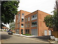
Chopin House apartments, Grieg Road, North Acton
View from Kathleen Avenue.
Image: © David Hawgood
Taken: 1 Jun 2019
0.03 miles
2
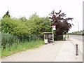
Bus stop on Western Avenue, North Acton
There used to be houses along this road, but they were knocked down to make way for an overpass . . which was then abandoned.
Image: © David Hawgood
Taken: 18 Jun 2006
0.03 miles
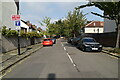
3
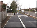
West end of cycle route C34, North Acton
This section of segregated cycle route just being finished runs from here to Savoy Circus (East Acton), existing sections being upgraded run to Wood Lane by White City. This view is of the end of Kathleen Avenue, now blocked off from the A40 Western Avenue seen on the right. This section of path and cycle track is also the western end of the Aviator Place housing estate.
Image: © David Hawgood
Taken: 11 Mar 2020
0.03 miles
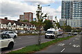
6
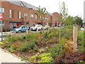
Terrace houses, Grieg Road, North Acton
The photo shows the planting for the "green corridor" between the housing and the busy Wester Avenue A40 road. There is a bus stop visible on the far right.
Image: © David Hawgood
Taken: 1 Jun 2019
0.05 miles
7
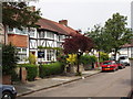
Wilfrid Gardens, North Acton
A variety of shrubs and trees in this suburban road.
Image: © David Hawgood
Taken: 18 Jun 2006
0.05 miles
8
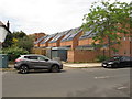
Solar panels, Grieg Road, North Acton
View from Allan Way. Grieg Road is part of the Aviator Place development. Solar panels are being installed on many of the houses in this development as they are built.
Image: © David Hawgood
Taken: 1 Jun 2019
0.05 miles
9
Benchmark on #33 Allan Way
Ordnance Survey cut mark benchmark described on the Bench Mark Database at http://www.bench-marks.org.uk/bm46938
Image: © Roger Templeman
Taken: 26 Jan 2013
0.05 miles
10
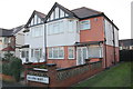
Semi-detached houses on Allan Way
There is an OS benchmark Image on the side of the right hand house, at the junction with the front porch extension
Image: © Roger Templeman
Taken: 26 Jan 2013
0.05 miles