IMAGES TAKEN NEAR TO
Queens Drive, LONDON, W3 0HT
Introduction
This page details the photographs taken nearby to Queens Drive, W3 0HT by members of the Geograph project.
The Geograph project started in 2005 with the aim of publishing, organising and preserving representative images for every square kilometre of Great Britain, Ireland and the Isle of Man.

There are currently over 7.5m images from over14,400 individuals and you can help contribute to the project by visiting https://www.geograph.org.uk
Image Map
Images are licensed for reuse under creativecommons.org/licenses/by-sa/2.0
Notes
- Clicking on the map will re-center to the selected point.
- The higher the marker number, the further away the image location is from the centre of the postcode.
Image Listing (155 Images Found)
Images are licensed for reuse under creativecommons.org/licenses/by-sa/2.0
Image
Details
Distance
1
Acton Yochien School
This is a primary school with teaching in Japanese - there is a Japanese High School nearby and many Japanese families live in the area. The buildings include the pavilion of the sports ground of Hanger Hill Garden Estate.
Image: © David Hawgood
Taken: 4 Apr 2010
0.02 miles
2
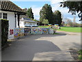
Hanger Hill Garden Estate Conservation Area
This shows the sign entering the estate from the West along Queen's Drive, with the privet hedges and one of the mock-Tudor apartment blocks characteristic of the area.
Image: © David Hawgood
Taken: 4 Apr 2010
0.02 miles
3
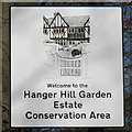
Sign for Hanger Hill Garden Estate Conservation Area
These pictorial signs have just been installed.
Image: © David Hawgood
Taken: 4 Apr 2010
0.03 miles
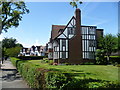
4
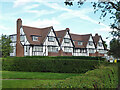
Inverness Court, Hanger Hill Estate
On an estate of buildings in similar style built between the wars.
Image: © Robin Webster
Taken: 6 Oct 2012
0.03 miles
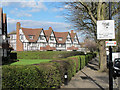
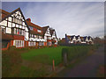
6
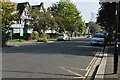
Houses in Queen's Drive
Ian Nairn's description of Queen's Drive in Nairn's London (1966) cannot be improved upon: "Queens Drive is strung between two geographical improbabilities called North Ealing and West Acton. This is a half-timbered square mile, and marvellous nonsense. Go and see!"
These houses are near the corner of Queen's Drive with Links Road.
Image: © Marathon
Taken: 13 Aug 2014
0.04 miles
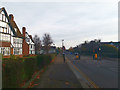
7
Queens Drive
Houses opposite Ellen Wilkinson High School.
Image: © James Emmans
Taken: 17 Nov 2019
0.05 miles
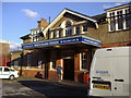
10
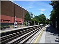
North Ealing station
North Ealing station was opened on 23rd June 1903 by the District Railway on its new extension from north of Ealing Common to Park Royal & Twyford Abbey. The line was opened fully to South Harrow on 28th June 1903.
This new extension was, together with the existing tracks between Ealing Common and Acton Town, the first section of the Underground's surface lines to be electrified and operate electric instead of steam trains.
On 4th July 1932 the Piccadilly line was extended to run west of its original terminus at Hammersmith sharing the route with the District line to Ealing Common. From Ealing Common to South Harrow, the District line was replaced by the Piccadilly line on this date.
This view from the down platform looks towards Park Royal.
Image: © Marathon
Taken: 13 Aug 2014
0.07 miles