IMAGES TAKEN NEAR TO
Queens Drive, LONDON, W3 0HH
Introduction
This page details the photographs taken nearby to Queens Drive, W3 0HH by members of the Geograph project.
The Geograph project started in 2005 with the aim of publishing, organising and preserving representative images for every square kilometre of Great Britain, Ireland and the Isle of Man.

There are currently over 7.5m images from over14,400 individuals and you can help contribute to the project by visiting https://www.geograph.org.uk
Image Map
Images are licensed for reuse under creativecommons.org/licenses/by-sa/2.0
Notes
- Clicking on the map will re-center to the selected point.
- The higher the marker number, the further away the image location is from the centre of the postcode.
Image Listing (156 Images Found)
Images are licensed for reuse under creativecommons.org/licenses/by-sa/2.0
Image
Details
Distance
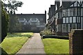
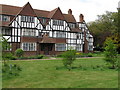
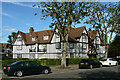
1
Oxford Court, Queen's Drive
Ian Nairn's description of Queen's Drive in Nairn's London (1966) cannot be improved upon: "Queens Drive is strung between two geographical improbabilities called North Ealing and West Acton. This is a half-timbered square mile, and marvellous nonsense. Go and see!"
There are three of these courts on the south side. This is Oxford Court. A notice at the gate tells all tradesmen to use rear entrance via service road.
Image: © Marathon
Taken: 13 Aug 2014
0.01 miles
2
Oxford Court, Queen's Drive
Ian Nairn's description of Queen's Drive in Nairn's London (1966) cannot be improved upon: "Queens Drive is strung between two geographical improbabilities called North Ealing and West Acton. This is a half-timbered square mile, and marvellous nonsense. Go and see!"
There are three of these courts on the south side. This is Oxford Court. A notice at the gate tells all tradesmen to use rear entrance via service road.
Image: © Marathon
Taken: 13 Aug 2014
0.01 miles
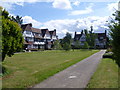
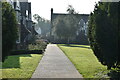
4
Flats, lawn and shrubs
This block of flats is part of a U-shaped array of flats facing onto a large grassed area with shrubs. The open end of the "U" is open to the road behind a low privet hedge. This block of flats is type B in the conservation area appraisal.
Image: © David Hawgood
Taken: 30 Apr 2010
0.02 miles
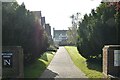
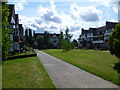
7
Queen's Drive
Ian Nairn's description of Queen's Drive in Nairn's London (1966) cannot be improved upon: "Queens Drive is strung between two geographical improbabilities called North Ealing and West Acton. This is a half-timbered square mile, and marvellous nonsense. Go and see!"
Image: © Marathon
Taken: 13 Aug 2014
0.04 miles
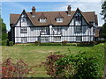
8
Housing on Hanger Hill Estate
An estate of buildings in similar style built between the wars.
Image: © Robin Webster
Taken: 6 Oct 2012
0.05 miles
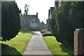
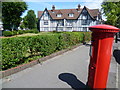
9
Houses in Queen's Drive
Ian Nairn's description of Queen's Drive in Nairn's London (1966) cannot be improved upon: "Queens Drive is strung between two geographical improbabilities called North Ealing and West Acton. This is a half-timbered square mile, and marvellous nonsense. Go and see!"
These houses are on the corner of Queen's Drive with Links Road.
Image: © Marathon
Taken: 13 Aug 2014
0.05 miles