IMAGES TAKEN NEAR TO
Cloister Road, LONDON, W3 0DF
Introduction
This page details the photographs taken nearby to Cloister Road, W3 0DF by members of the Geograph project.
The Geograph project started in 2005 with the aim of publishing, organising and preserving representative images for every square kilometre of Great Britain, Ireland and the Isle of Man.

There are currently over 7.5m images from over14,400 individuals and you can help contribute to the project by visiting https://www.geograph.org.uk
Image Map
Images are licensed for reuse under creativecommons.org/licenses/by-sa/2.0
Notes
- Clicking on the map will re-center to the selected point.
- The higher the marker number, the further away the image location is from the centre of the postcode.
Image Listing (294 Images Found)
Images are licensed for reuse under creativecommons.org/licenses/by-sa/2.0
Image
Details
Distance
1
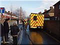
Fireman running out hose
House at end of Cloister Road was on fire, the hydrant is at the junction of Cloister and Balfour roads.
Image: © David Hawgood
Taken: 3 Mar 2007
0.01 miles
2
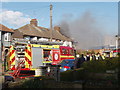
Fire engine in action
Image: © David Hawgood
Taken: 3 Mar 2007
0.01 miles
3
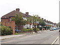
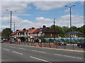
Park View, North Acton
This street has 1930s terrace houses, each block has four houses, between each block is access to a service road and garages behind the houses. The shrubs on the far left are part of a site where houses were demolished to make way for an overpass on Western Avenue. The road project was abandoned. Recently Transport for London tried to turn the vacant land into a bus depot, but thankfully their plans have been rejected.
Image: © David Hawgood
Taken: 16 Sep 2006
0.02 miles
4
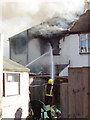
Firefighting
Firemen direct two jets of water into the back bedroom of a house in Cloister Road. View from service road behind houses.
Image: © David Hawgood
Taken: 3 Mar 2007
0.02 miles
5
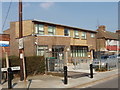
Doctors' surgery, Cloister Road, North Acton
New building opened in February 2006, on a site where there used to be a scout hut, next to a clinic built 1935 which is now a day hospital. View north-east
Image: © David Hawgood
Taken: 15 Mar 2006
0.03 miles
6
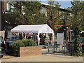
Well organised flu jab clinic at Cloister Road surgery with social distancing
In coronavirus time the surgery organised flu vaccination for over-65s with a notice board of instructions, temporary shelter while waiting, several vaccination stations in the waiting room area, and a route out through the staff entrance so leaving patients avoid arriving ones.
Image: © David Hawgood
Taken: 19 Sep 2020
0.03 miles
7
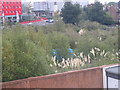
Camp on TfL land, Gipsy Corner
At a meeting of West Acton Residents Association, residents in Park View reported that there were people living in tents on this piece of land. The land was acquired for a road development which was later cancelled, and now belongs to Transport for London. Squatters have recently been evicted from nearby house belonging to TfL. Photo from a house in Park View. See Image for photo with one of the campers visible.
Image: © David Hawgood
Taken: 13 Oct 2011
0.03 miles
8
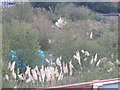
Unauthorised camper on TfL land at Gipsy Corner
At a meeting of West Acton Residents Association, residents in Park View reported that there were people living in tents on this piece of land. The land was acquired for a road development which was later cancelled, and now belongs to Transport for London. Squatters have recently been evicted from nearby houses belonging to TfL. Photo from a house in Park View. See Image for general view of the site.
Image: © David Hawgood
Taken: 13 Oct 2011
0.03 miles
9
Western Avenue at Gipsy Corner
The houses are on the north-east side of Western Avenue. View from western corner of Gipsy Corner crossroads.
Image: © David Hawgood
Taken: 28 May 2006
0.04 miles
10
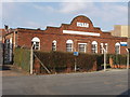
Cloister Road Clinic, North Acton
Now used as Gunnersbury Day Hospital, it was built in 1935 when there was a great expansion of popuilation in the area. It is included as a Locally Listed Building of architectural or historical interest in Ealing Borough's new plan for the environment in http://www.ealing.gov.uk/services/environment/planning/planning_policy/new_plan_for_the_environment/
[edit January 2019] The site has been redeveloped as four town houses. The first plans kept the facade, but in the event no part of the 1935 building was retained
Image: © David Hawgood
Taken: 18 Mar 2006
0.05 miles