IMAGES TAKEN NEAR TO
Highfield Road, LONDON, W3 0AJ
Introduction
This page details the photographs taken nearby to Highfield Road, W3 0AJ by members of the Geograph project.
The Geograph project started in 2005 with the aim of publishing, organising and preserving representative images for every square kilometre of Great Britain, Ireland and the Isle of Man.

There are currently over 7.5m images from over14,400 individuals and you can help contribute to the project by visiting https://www.geograph.org.uk
Image Map
Images are licensed for reuse under creativecommons.org/licenses/by-sa/2.0
Notes
- Clicking on the map will re-center to the selected point.
- The higher the marker number, the further away the image location is from the centre of the postcode.
Image Listing (101 Images Found)
Images are licensed for reuse under creativecommons.org/licenses/by-sa/2.0
Image
Details
Distance
1
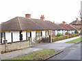
Highfield Road, North Acton
Bungalows on the north side of the part of Highfield Road that runs SW to NE.
Image: © David Hawgood
Taken: 15 Jan 2006
0.04 miles
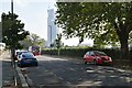
2
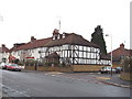
Northfields, North Acton
Junction of Highfield Road
Image: © David Hawgood
Taken: 15 Jan 2006
0.07 miles
3
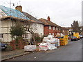
Building work in Highfield Road, North Acton
Looking north in the part of the road running north-south.
Image: © David Hawgood
Taken: 15 Jan 2006
0.07 miles
4
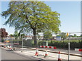
Power cable joint bay
Once these roadworks in Northfields Road North Acton are complete there won't be any sign of the underground power cable. One of the joints in the Wimbledon to Willesden power line is under the dark patch in the road with a lighter area inset. Signs on the road works say it is Balfour Beatty Power Networks working on behalf of the National Grid on a joint bay refurbishment project. The work seems to have been complete for over a week but signs say "Materials curing - please be patient".
[Edit in May 2020] The cables have been removed, see Image
Image: © David Hawgood
Taken: 1 May 2007
0.07 miles
6
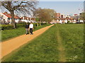
Social distancing wears new path in grass, North Acton
Many local people use this park for their permitted daily exercise during the lock-down of the coronavirus pandemic. To keep the recommended 6 feet from others some walk or jog that distance away from the gravel path along one side. The result is this path worn in the grass. The road on the left is Northfields, the one facing is Eastfields.
Image: © David Hawgood
Taken: 15 Apr 2020
0.07 miles
7
London high voltage cables decommissioned, North Acton
The Willesden to Wimbledon high voltage oil-insulated cables ran under here. Maintenance work on the joint bay in 2007 is shown in photo Image The cables have been replaced by ones in deeper tunnels; the one from Willesden to Wimbledon runs via Kensal Green and does not go under here. The darker patches of tarmac now are where there were cabinets on the pavement, and recently a deep pit in the roadway through which the oil was extracted.
Image: © David Hawgood
Taken: 16 May 2020
0.08 miles
8
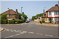
Alliance Road
View north west up Alliance Road from Northfields Road.
Image: © David P Howard
Taken: 12 Jul 2013
0.09 miles
9
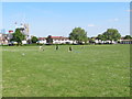
Family rounders during coronavirus pandemic, North Acton
During the pandemic exercise is only allowed alone keeping apart from others, or just with members of the same household. So here a family is playing rounders on North Acton Playing Field, well away from other users of the park.
Image: © David Hawgood
Taken: 8 May 2020
0.09 miles
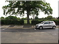
10
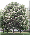
Horse chestnut tree in flower, North Acton Recreation Ground
This tree is in the north-west corner of the field. There are other trees around the edge of the field.
Image: © David Hawgood
Taken: 14 May 2006
0.09 miles