IMAGES TAKEN NEAR TO
Eastfields Road, LONDON, W3 0AA
Introduction
This page details the photographs taken nearby to Eastfields Road, W3 0AA by members of the Geograph project.
The Geograph project started in 2005 with the aim of publishing, organising and preserving representative images for every square kilometre of Great Britain, Ireland and the Isle of Man.

There are currently over 7.5m images from over14,400 individuals and you can help contribute to the project by visiting https://www.geograph.org.uk
Image Map
Images are licensed for reuse under creativecommons.org/licenses/by-sa/2.0
Notes
- Clicking on the map will re-center to the selected point.
- The higher the marker number, the further away the image location is from the centre of the postcode.
Image Listing (283 Images Found)
Images are licensed for reuse under creativecommons.org/licenses/by-sa/2.0
Image
Details
Distance
1
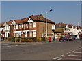
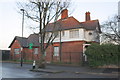
Former doctors' surgery, Eastfields Road, North Acton
Corner of Eastfields and Noel Roads, view north-east across Noel Road. The house on the corner was a doctors' surgery up to February 2006. The practice has moved to a purpose-built surgery, see Image Thirty years ago, the practice was in the garage of the vicarage.
Image: © David Hawgood
Taken: 15 Mar 2006
0.02 miles
2
North Acton Playing Field 1980, tennis courts
View towards Eastfields, and St Gabriel's church. In 2019 the tennis courts are well maintained and in regular use. Scan of 35mm Kodachrome slide.
Image: © David Hawgood
Taken: Unknown
0.02 miles
3
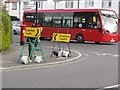
Conflicting traffic diversions, North Acton
Contractors working on roads which joined A40 Western Avenue suggest diversion to the left. Contractors working in Northfields suggest diversion to the right. The 218 bus shown is on diversion, continuing on Noel Road instead of going around North Acton playing field.
Image: © David Hawgood
Taken: 13 Mar 2020
0.03 miles
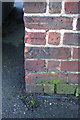
4
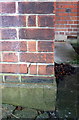
Benchmark on lodge in North Acton Playing Fields
Ordnance Survey cut mark benchmark described on the Bench Mark Database at http://www.bench-marks.org.uk/bm46942
Image: © Roger Templeman
Taken: 26 Jan 2013
0.04 miles
5
Noel Road lodge in North Acton Playing Fields
There is an OS benchmark Image on the front near corner of the building
Image: © Roger Templeman
Taken: 26 Jan 2013
0.04 miles
6
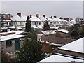
North Acton houses in snow
An inch of snow fell during the night and settled. This photo was taken at 10 a.m., by 1 p.m. almost all the snow had melted. View from a house in Cloister Road to the backs of a terrace of houses in Cecil Road. There is a service road along the backs of the houses, with garages. Some houses have loft conversions, changing them from 3-bedroom to 4-bedroom. Viewpoint first floor window, same as Image
Image: © David Hawgood
Taken: 24 Jan 2007
0.04 miles
7
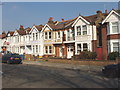
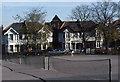
Eastfields Road, North Acton
Houses facing playing fields. These are between Cloister and Cecil Roads, view north-east.
Image: © David Hawgood
Taken: 15 Mar 2006
0.04 miles
8
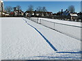
Shadow of tennis net on fresh snow
On a bright morning after a snowfall the snow on the North Acton Playing Field tennis court was undisturbed giving a sharp shadow.
Image: © David Hawgood
Taken: 25 Jan 2021
0.05 miles
9
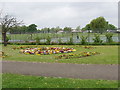
Tennis courts and flower bed, North Acton playing field
This park is mainly used for sport, and this flower bed is one of just a few decorative features. The tennis courts are well used all year, with active tennis coaching particularly of children.
Image: © David Hawgood
Taken: 14 May 2006
0.05 miles
10
Benchmark on St Gabriel's Church
Ordnance Survey cut mark benchmark described on the Bench Mark Database at http://www.bench-marks.org.uk/bm23425
Image: © Roger Templeman
Taken: 26 Jan 2013
0.05 miles