IMAGES TAKEN NEAR TO
Hallfield Estate, LONDON, W2 6HE
Introduction
This page details the photographs taken nearby to Hallfield Estate, W2 6HE by members of the Geograph project.
The Geograph project started in 2005 with the aim of publishing, organising and preserving representative images for every square kilometre of Great Britain, Ireland and the Isle of Man.

There are currently over 7.5m images from over14,400 individuals and you can help contribute to the project by visiting https://www.geograph.org.uk
Image Map
Images are licensed for reuse under creativecommons.org/licenses/by-sa/2.0
Notes
- Clicking on the map will re-center to the selected point.
- The higher the marker number, the further away the image location is from the centre of the postcode.
Image Listing (230 Images Found)
Images are licensed for reuse under creativecommons.org/licenses/by-sa/2.0
Image
Details
Distance
1
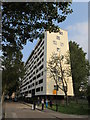
Reading House, Hallfield Estate
One of the 14 Grade II listed blocks of the Estate on Leinster Gardens.
As seen from an access road passing through the estate.
See http://www.britishlistedbuildings.co.uk/en-1402283-hallfield-estate-14-residential-blocks- for more details on the estate.
Image: © David Anstiss
Taken: 6 Sep 2014
0.01 miles
2
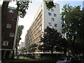
Reading House, Hallfield Estate
One of the 14 Grade II listed blocks of the Estate on Leinster Gardens.
See http://www.britishlistedbuildings.co.uk/en-1402283-hallfield-estate-14-residential-blocks- for more details on the estate.
Image: © David Anstiss
Taken: 6 Sep 2014
0.01 miles
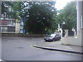
3
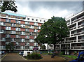
Hallfield Estate, Bishop's Bridge Road (1)
A London County Council estate into which it is evident that more thought than usual was invested in its design, appearance and layout. It consists of six ten-storey slabs and eight six-storey slabs arranged at 45 degrees to the surrounding roads and generously endowed with green space and trees. Also included in the plan were schools, a laundry and shops. The varied, patterned facades betray the involvement of Berthold Lubetkin of Tecton, although after the firm was dissolved execution fell to Denys Lasdun and Lindsay Drake. It was not, however, without criticism. Pevsner wrote that the "formal planning [subordinates] the individual unit to the whole and to some extent sacrifices private convenience to this grand aim", but concluded thus: "the total design has a visual force and character that distinguish it from much public housing of the 1950s". It was designed from 1947 and completed in 1955. Grade II listed.
See also Image] and Image
Image: © Stephen Richards
Taken: 17 Jul 2011
0.02 miles
4
Cleveland Gardens from Leinster Gardens
Image: © David Howard
Taken: 25 Aug 2012
0.03 miles
5
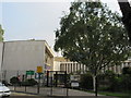
Hallfield Primary School
This brick and concrete school was designed by Lindsay Drake and Denys Lasdun. Built in 1953. As part of a group with the Hallfield Estate.
Then Grade II* listed in 1988.
See http://www.britishlistedbuildings.co.uk/en-428783-hallfield-school-greater-london-authorit for more details.
Image: © David Anstiss
Taken: 6 Sep 2014
0.04 miles
6

View from Hallfield Estate
Not a bad view from the top of one of the ten-storey blocks (Image]).
The prominent buildings are 20 Eastbourne Terrace (Image]), the Water Gardens (Image]), the Quadrangle (Image]) and its sister, Marble Arch Tower (Image]), the Shard (faintly), and the London Eye (Image]).
Image: © Stephen Richards
Taken: 17 Jul 2011
0.04 miles
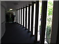
7
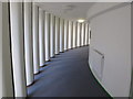
Curving corridor, Hallfield Primary School
This was designed by Denys Lasdun, built in 1951. Walking this way one sees a pattern of light from the windows between the pillars. Walking the other way one sees through the glass windows.
Image: © David Hawgood
Taken: 20 Sep 2015
0.04 miles
8
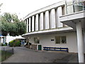
Hallfield Primary School, entrance and curving corridor
Image: © David Hawgood
Taken: 20 Sep 2015
0.04 miles
9
Windows in curving corridor, Hallfield Primary School
This is the opposite view to Image, in the school designed in 1951 by Denys Lasdun.
Image: © David Hawgood
Taken: 20 Sep 2015
0.05 miles