IMAGES TAKEN NEAR TO
Celbridge Mews, LONDON, W2 6EU
Introduction
This page details the photographs taken nearby to Celbridge Mews, W2 6EU by members of the Geograph project.
The Geograph project started in 2005 with the aim of publishing, organising and preserving representative images for every square kilometre of Great Britain, Ireland and the Isle of Man.

There are currently over 7.5m images from over14,400 individuals and you can help contribute to the project by visiting https://www.geograph.org.uk
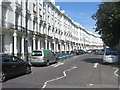
Image Map
Images are licensed for reuse under creativecommons.org/licenses/by-sa/2.0
Notes
- Clicking on the map will re-center to the selected point.
- The higher the marker number, the further away the image location is from the centre of the postcode.
Image Listing (223 Images Found)
Images are licensed for reuse under creativecommons.org/licenses/by-sa/2.0
Image
Details
Distance
2
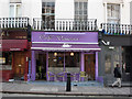
Cafe Venezia, W2
The picture was taken for no reason other than its garish colour scheme.
In Porchester Road, W2
Image: © Phillip Perry
Taken: 29 Mar 2007
0.03 miles

4
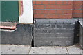
Benchmark on #66 Porchester Road at its junction with Lord Hill's Bridge
Ordnance Survey cut mark benchmark described on the Bench Mark Database at http://www.bench-marks.org.uk/bm38009
Image: © Roger Templeman
Taken: 20 May 2011
0.03 miles
5
Lord Hills Bridge at north end of Porchester Road
There is an OS benchmark at the junction of the bridge and the building on the right hand side of photo Image
Image: © Roger Templeman
Taken: 20 May 2011
0.03 miles
6
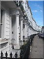
Gloucester Terrace W2
Unusually, the houses on the other side of the road have a different address - Porchester Square.
Image: © Rod Allday
Taken: 3 Sep 2011
0.03 miles
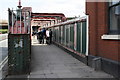
8
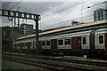
Royal Oak underground station from passing train
Image: © Christopher Hilton
Taken: 22 Jun 2013
0.04 miles
9
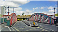
Entrance to Royal Oak station, over Lord Hill's Bridge, 2010
View north from Porchester Road over all the ex-GWR and Hammersmith & City tracks to Harrow Road with Westway above it.
Image: © Ben Brooksbank
Taken: 17 Sep 2010
0.04 miles
10

View across the main lines out of Paddington seen from Royal Oak station
The Hammersmith & City Railway (H&CR) opened on 13th June 1864 between Westbourne Park and Hammersmith stations and the West London Railway (WLR) opened on 1st July 1864. This left the H&CR line at what is now Latimer Road to reach Addison Road (now Kensington Olympia). Subsequently an agreement was made between the Great Western Railway (GWR) and the Metropolitan Railway (who had co-owned the Hammersmith & City with the GWR since 1867) which came into force on 1st July 1868. Under this agreement various improvements were to be made including the provision of a station at Royal Oak, and the reconstruction of Westbourne Park. Royal Oak station opened on 30th October 1871. In 1878 when the Great Western Main Line was being quadrupled a dive-under was constructed between Royal Oak and Westbourne Park. From its opening Royal Oak was served by both main line and Hammersmith & City trains, and, for over sixty years, this was the first stop out of Paddington for main line trains. Trains along the Great Western Main Line ceased to call at Royal Oak from 1st October 1934.
Trains on the Hammersmith & City Line serve the station and now also, in an effort to improve its reliability, the Circle Line. The next station in this direction on the Hammersmith & City Line is Westbourne Park, and the next station on the Great Western route is Acton Main Line.
Image: © Marathon
Taken: 6 Nov 2013
0.04 miles