IMAGES TAKEN NEAR TO
Porchester Road, LONDON, W2 6ET
Introduction
This page details the photographs taken nearby to Porchester Road, W2 6ET by members of the Geograph project.
The Geograph project started in 2005 with the aim of publishing, organising and preserving representative images for every square kilometre of Great Britain, Ireland and the Isle of Man.

There are currently over 7.5m images from over14,400 individuals and you can help contribute to the project by visiting https://www.geograph.org.uk
Image Map
Images are licensed for reuse under creativecommons.org/licenses/by-sa/2.0
Notes
- Clicking on the map will re-center to the selected point.
- The higher the marker number, the further away the image location is from the centre of the postcode.
Image Listing (214 Images Found)
Images are licensed for reuse under creativecommons.org/licenses/by-sa/2.0
Image
Details
Distance
1
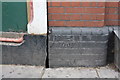
Benchmark on #66 Porchester Road at its junction with Lord Hill's Bridge
Ordnance Survey cut mark benchmark described on the Bench Mark Database at http://www.bench-marks.org.uk/bm38009
Image: © Roger Templeman
Taken: 20 May 2011
0.02 miles
2
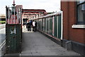
Lord Hills Bridge at north end of Porchester Road
There is an OS benchmark at the junction of the bridge and the building on the right hand side of photo Image
Image: © Roger Templeman
Taken: 20 May 2011
0.02 miles
3
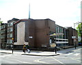
Westbourne Park Baptist Church, London W2
The church is on the corner of Porchester Road and Westbourne Park Villas,
near the southern end of Lord Hills Bridge. http://www.geograph.org.uk/photo/3137452
Image: © Jaggery
Taken: 13 May 2012
0.03 miles
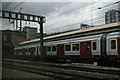
4
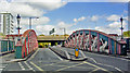
Entrance to Royal Oak station, over Lord Hill's Bridge, 2010
View north from Porchester Road over all the ex-GWR and Hammersmith & City tracks to Harrow Road with Westway above it.
Image: © Ben Brooksbank
Taken: 17 Sep 2010
0.03 miles

6
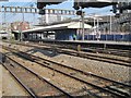
Royal Oak Underground station, London
Opened in 1871 jointly by the Great Western Railway and (what is now) the Hammersmith & City Line, just outside London Paddington. The GWR ceased serving here in 1934.
View west from a passing Great Western train. Like 55% of the London Underground network, this part is actually overground.
Image: © Nigel Thompson
Taken: 11 Aug 2012
0.04 miles
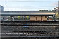
9
Royal Oak underground station from passing train
Image: © Christopher Hilton
Taken: 22 Jun 2013
0.04 miles
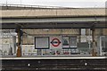
10
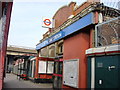
Royal Oak Tube
Royal Oak Tube Station on the Hammersmith and City line
Image: © Oxyman
Taken: 12 Mar 2007
0.04 miles