IMAGES TAKEN NEAR TO
Harrow Road, LONDON, W2 5XQ
Introduction
This page details the photographs taken nearby to Harrow Road, W2 5XQ by members of the Geograph project.
The Geograph project started in 2005 with the aim of publishing, organising and preserving representative images for every square kilometre of Great Britain, Ireland and the Isle of Man.

There are currently over 7.5m images from over14,400 individuals and you can help contribute to the project by visiting https://www.geograph.org.uk
Image Map
Images are licensed for reuse under creativecommons.org/licenses/by-sa/2.0
Notes
- Clicking on the map will re-center to the selected point.
- The higher the marker number, the further away the image location is from the centre of the postcode.
Image Listing (319 Images Found)
Images are licensed for reuse under creativecommons.org/licenses/by-sa/2.0
Image
Details
Distance
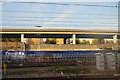
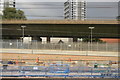
4
A40 flyover (Westway)
With crossrail construction in front.
Image: © N Chadwick
Taken: 22 Feb 2014
0.04 miles
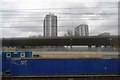
6
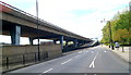
A view west along Harrow Road and Westway, London
Viewed from the corner of Westbourne Terrace Road. http://www.geograph.org.uk/photo/3137135
The elevated Westway is alongside Harrow Road.
Image: © Jaggery
Taken: 13 May 2012
0.05 miles
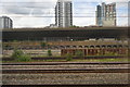
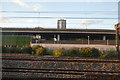
7
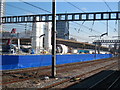
Crossrail works alongside the main line approaching Paddington station
Crossrail is a huge engineering project to provide an east-west rail link across London. In the centre of the photo is a tunnelling machine awaiting mobilisation.
Image: © Rod Allday
Taken: 26 Feb 2012
0.06 miles
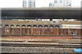
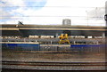
8
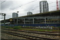
Crossrail works, west of Paddington
Image: © Christopher Hilton
Taken: 22 Jun 2013
0.06 miles