IMAGES TAKEN NEAR TO
St. Stephens Crescent, LONDON, W2 5QT
Introduction
This page details the photographs taken nearby to St. Stephens Crescent, W2 5QT by members of the Geograph project.
The Geograph project started in 2005 with the aim of publishing, organising and preserving representative images for every square kilometre of Great Britain, Ireland and the Isle of Man.

There are currently over 7.5m images from over14,400 individuals and you can help contribute to the project by visiting https://www.geograph.org.uk
Image Map
Images are licensed for reuse under creativecommons.org/licenses/by-sa/2.0
Notes
- Clicking on the map will re-center to the selected point.
- The higher the marker number, the further away the image location is from the centre of the postcode.
Image Listing (227 Images Found)
Images are licensed for reuse under creativecommons.org/licenses/by-sa/2.0
Image
Details
Distance
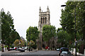
1
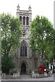
St Stephen's Church
At the junction of Talbot Road and Westbourne Park Road
Image: © Roger Templeman
Taken: 13 May 2011
0.04 miles
2
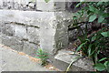
Benchmark on buttress of St Stephen's Church
Ordnance Survey cut mark benchmark described on the Bench Mark Database at http://www.bench-marks.org.uk/bm37938
Image: © Roger Templeman
Taken: 13 May 2011
0.04 miles
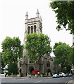
3
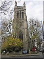
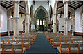
St Stephen's Church, Westbourne Park
Image: © Roger Cornfoot
Taken: 29 Nov 2014
0.04 miles
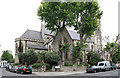
4
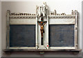
St Stephen, Westbourne Park Road - War Memorial
Image: © John Salmon
Taken: 16 May 2011
0.05 miles
5
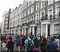
Notting Hill Carnival - 2013
Chepstow Road.
Image: © Fernweh
Taken: 25 Aug 2013
0.06 miles
6

Notting Hill Carnival - 2013
Waiting for the rest of the group.
Image: © Fernweh
Taken: 25 Aug 2013
0.06 miles
10
St Stephen, Westbourne Park Road - East end
Image: © John Salmon
Taken: 16 May 2011
0.06 miles