IMAGES TAKEN NEAR TO
Durham Terrace, LONDON, W2 5PB
Introduction
This page details the photographs taken nearby to Durham Terrace, W2 5PB by members of the Geograph project.
The Geograph project started in 2005 with the aim of publishing, organising and preserving representative images for every square kilometre of Great Britain, Ireland and the Isle of Man.

There are currently over 7.5m images from over14,400 individuals and you can help contribute to the project by visiting https://www.geograph.org.uk
Image Map
Images are licensed for reuse under creativecommons.org/licenses/by-sa/2.0
Notes
- Clicking on the map will re-center to the selected point.
- The higher the marker number, the further away the image location is from the centre of the postcode.
Image Listing (232 Images Found)
Images are licensed for reuse under creativecommons.org/licenses/by-sa/2.0
Image
Details
Distance
1
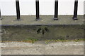
Benchmark on wall of #31 Westbourne Park Road
Ordnance Survey cut mark benchmark described on the Bench Mark Database at http://www.bench-marks.org.uk/bm37940
Image: © Roger Templeman
Taken: 13 May 2011
0.03 miles
2
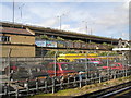
A40 'Westway' London W2
Picture taken from Royal Oak Hammersmith & City underground station.
Image: © Chris McMillan
Taken: 24 May 2005
0.07 miles
3
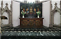
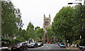
St Stephen, Westbourne Park Road - Sanctuary
Image: © John Salmon
Taken: 16 May 2011
0.07 miles
4
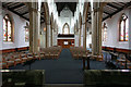
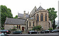
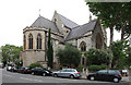
St Stephen, Westbourne Park Road - West end
Image: © John Salmon
Taken: 16 May 2011
0.07 miles
6
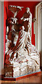
St Stephen, Westbourne Park Road - Monument
Image: © John Salmon
Taken: 16 May 2011
0.08 miles
7
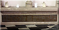
St Stephen, Westbourne Park Road - Brass
Image: © John Salmon
Taken: 16 May 2011
0.08 miles
10

St Stephen, Westbourne Park Road - East end
Image: © John Salmon
Taken: 16 May 2011
0.08 miles