IMAGES TAKEN NEAR TO
Monmouth Road, LONDON, W2 4UU
Introduction
This page details the photographs taken nearby to Monmouth Road, W2 4UU by members of the Geograph project.
The Geograph project started in 2005 with the aim of publishing, organising and preserving representative images for every square kilometre of Great Britain, Ireland and the Isle of Man.

There are currently over 7.5m images from over14,400 individuals and you can help contribute to the project by visiting https://www.geograph.org.uk
Image Map
Images are licensed for reuse under creativecommons.org/licenses/by-sa/2.0
Notes
- Clicking on the map will re-center to the selected point.
- The higher the marker number, the further away the image location is from the centre of the postcode.
Image Listing (236 Images Found)
Images are licensed for reuse under creativecommons.org/licenses/by-sa/2.0
Image
Details
Distance
1

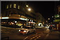
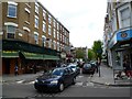
Ned's Noodle Bar, London W2
Ned's Noodle Bar is on the corner of Westbourne Grove and Monmouth Road.
Neighbouring business are Dar Al Dawa Bookshop and "99" Dry Cleaners.
Image: © Jaggery
Taken: 13 May 2012
0.01 miles
2
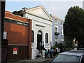
Kingdom Hall, Monmouth Road
Small Grade II listed hall at No10.
Currently used by Jehovahs Witnesses.
See http://www.britishlistedbuildings.co.uk/en-418437-11-monmouth-road-w2-greater-london-autho for more details about the building.
Image: © David Anstiss
Taken: 6 Sep 2014
0.01 miles
3
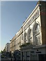
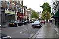
Buildings on Westbourne Grove Road, W2
These buildings are on the north side of the road just east of Monmouth Road; the junction is by the yellow van. The rather grand facade with arched windows is over what was a bank and is now a salon. The reflection at top right is explained by the fact that this was taken from the top floor of a number 27 bus.
Image: © Derek Harper
Taken: 14 Oct 2011
0.04 miles
5

Alwaha Restaurant, London W2
Lebanese cuisine restaurant on the corner of Westbourne Grove and Garway Road.
Image: © Jaggery
Taken: 13 May 2012
0.04 miles
6
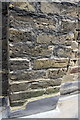
Benchmark on #6 Hereford Road
Ordnance Survey cut mark benchmark described on the Bench Mark Database at http://www.bench-marks.org.uk/bm37936
Image: © Roger Templeman
Taken: 13 May 2011
0.04 miles
7
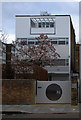
32 Newton Road, Bayswater, London W2
Grade II listed Modernist house built in 1938 to the designs of Denys Lasdun.
Description at this https://historicengland.org.uk/listing/the-list/list-entry/1224989. At one time the house was lived in by cartoonist Ronald Searle - see this http://ronaldsearle.blogspot.co.uk/2012/07/at-home-with-searles.html . For more on the architecture of the house and the architect see this http://www.ribablogs.com/?p=6037.
Image: © Jim Osley
Taken: 3 Mar 2016
0.05 miles
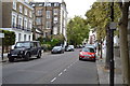
10
Hereford Road London W2
A view south across Westbourne Grove, Bayswater.
Image: © Jaggery
Taken: 13 May 2012
0.07 miles