IMAGES TAKEN NEAR TO
Chepstow Place, LONDON, W2 4TS
Introduction
This page details the photographs taken nearby to Chepstow Place, W2 4TS by members of the Geograph project.
The Geograph project started in 2005 with the aim of publishing, organising and preserving representative images for every square kilometre of Great Britain, Ireland and the Isle of Man.

There are currently over 7.5m images from over14,400 individuals and you can help contribute to the project by visiting https://www.geograph.org.uk
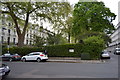
Image Map
Images are licensed for reuse under creativecommons.org/licenses/by-sa/2.0
Notes
- Clicking on the map will re-center to the selected point.
- The higher the marker number, the further away the image location is from the centre of the postcode.
Image Listing (285 Images Found)
Images are licensed for reuse under creativecommons.org/licenses/by-sa/2.0
Image
Details
Distance
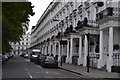
2
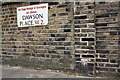
Benchmark on wall pier of #6 Dawson Place
Ordnance Survey cut mark benchmark described on the Bench Mark Database at http://www.bench-marks.org.uk/bm37944
Image: © Roger Templeman
Taken: 13 May 2011
0.02 miles
4
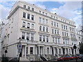
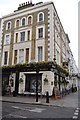
61 - 69, Chepstow Place
Row of Grade II listed houses on Chepstow Place, near Pembridge Square.
Image: © David Anstiss
Taken: 14 Apr 2013
0.03 miles
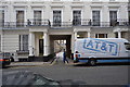
9
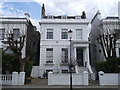
No.9 Dawson Place, Notting Hill
Most of the houses in this area are painted white to match.
Image: © David Anstiss
Taken: 14 Apr 2013
0.06 miles