IMAGES TAKEN NEAR TO
Dawson Place, LONDON, W2 4TJ
Introduction
This page details the photographs taken nearby to Dawson Place, W2 4TJ by members of the Geograph project.
The Geograph project started in 2005 with the aim of publishing, organising and preserving representative images for every square kilometre of Great Britain, Ireland and the Isle of Man.

There are currently over 7.5m images from over14,400 individuals and you can help contribute to the project by visiting https://www.geograph.org.uk
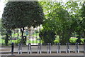
Image Map
Images are licensed for reuse under creativecommons.org/licenses/by-sa/2.0
Notes
- Clicking on the map will re-center to the selected point.
- The higher the marker number, the further away the image location is from the centre of the postcode.
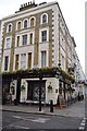
Image Listing (307 Images Found)
Images are licensed for reuse under creativecommons.org/licenses/by-sa/2.0
Image
Details
Distance
1
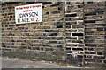
Benchmark on wall pier of #6 Dawson Place
Ordnance Survey cut mark benchmark described on the Bench Mark Database at http://www.bench-marks.org.uk/bm37944
Image: © Roger Templeman
Taken: 13 May 2011
0.02 miles
2
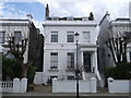
No.9 Dawson Place, Notting Hill
Most of the houses in this area are painted white to match.
Image: © David Anstiss
Taken: 14 Apr 2013
0.03 miles
3
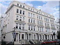
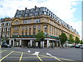
61 - 69, Chepstow Place
Row of Grade II listed houses on Chepstow Place, near Pembridge Square.
Image: © David Anstiss
Taken: 14 Apr 2013
0.04 miles
8
Baynards, 1 Chepstow Place, Notting Hill, London W2
Baynards extends for nearly 100 metres from Westbourne Grove along the east side of Chepstow Place. Baynards is mixture of rented and privately-owned apartments.
Image: © Jaggery
Taken: 13 May 2012
0.08 miles
9

Old Boundary Marker by Pembridge Square, Paddington, Bayswater and Knightsbridge Parish
Parish Boundary Marker by the UC road, in parish of Paddington, Bayswater and Knightsbridge (City of Westminster District), Pembridge Square W2, East end of street, in pavement next to kerb by No 19 Pembridge Square, junction with Moscow Road.
Inscription reads:- : NO. 18. M.B.P. 1900 / IN THE CENTRE OF THE / TWO ROADS OPPOSITE IS THE / BOUNDARY OF PADDINGTON :
Surveyed
Milestone Society National ID: MX_PADDB25pb
Image: © Milestone Society
Taken: Unknown
0.09 miles