IMAGES TAKEN NEAR TO
Orme Square, LONDON, W2 4RS
Introduction
This page details the photographs taken nearby to Orme Square, W2 4RS by members of the Geograph project.
The Geograph project started in 2005 with the aim of publishing, organising and preserving representative images for every square kilometre of Great Britain, Ireland and the Isle of Man.

There are currently over 7.5m images from over14,400 individuals and you can help contribute to the project by visiting https://www.geograph.org.uk
Image Map
Images are licensed for reuse under creativecommons.org/licenses/by-sa/2.0
Notes
- Clicking on the map will re-center to the selected point.
- The higher the marker number, the further away the image location is from the centre of the postcode.
Image Listing (334 Images Found)
Images are licensed for reuse under creativecommons.org/licenses/by-sa/2.0
Image
Details
Distance
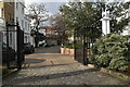
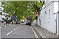
4
Orme Court from Bayswater Road, London
Image: © Christine Matthews
Taken: 31 Jul 2013
0.02 miles
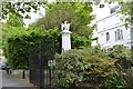
7
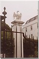
Eagle Pillar
The eagle pillar in Orme Square has an uncertain history; its sculptor is unknown, as is the reason for its being where it is. Indeed it may not even be an eagle at all; it has been suggested that it is a phoenix, and originally was the symbol of a fire insurance company. A nearby house has birds looking like phoenixes in its frontage, so this could be correct.
Image: © Jonathan Ormond
Taken: Unknown
0.03 miles
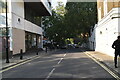
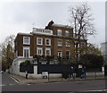
9
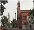
Bayswater, London W2
A view along St Petersburgh Place with the Grade 1-listed New West End Synagogue on the right and the Grade II* listed St Matthew's Anglican Church, with its 240 feet or 73 metres high spire, in the distance. Bayswater Road (i.e. the A402) and the northern boundary of Hyde Park lie less than 100 metres behind the photographer.
Image: © David Hallam-Jones
Taken: 4 Sep 2014
0.03 miles
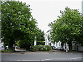
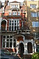
10
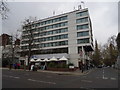
DoubleTree by Hilton Hotel and Urban Meadow Cafe
Bayswater Road, London W2.
Image: © JThomas
Taken: 13 Apr 2019
0.03 miles