IMAGES TAKEN NEAR TO
Pembridge Square, LONDON, W2 4ED
Introduction
This page details the photographs taken nearby to Pembridge Square, W2 4ED by members of the Geograph project.
The Geograph project started in 2005 with the aim of publishing, organising and preserving representative images for every square kilometre of Great Britain, Ireland and the Isle of Man.

There are currently over 7.5m images from over14,400 individuals and you can help contribute to the project by visiting https://www.geograph.org.uk
Image Map
Images are licensed for reuse under creativecommons.org/licenses/by-sa/2.0
Notes
- Clicking on the map will re-center to the selected point.
- The higher the marker number, the further away the image location is from the centre of the postcode.
Image Listing (390 Images Found)
Images are licensed for reuse under creativecommons.org/licenses/by-sa/2.0
Image
Details
Distance
2
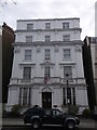
Pembridge Hall
Imperial College Hall of Residence
Image: © Rob Motha
Taken: 18 Sep 2011
0.06 miles
3

Prince Edward Mansions
The building is at the junction of Hereford Road and Pembridge Square: the photograph taken from the latter.
Image: © Roger Templeman
Taken: 13 May 2011
0.06 miles
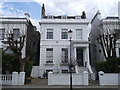
4
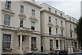
Notting Hill Hotel
No.2 Pembridge Square. A Grade II listed building overlooking the gardens of Pembridge Square.
Image: © David Anstiss
Taken: 14 Apr 2013
0.07 miles
5
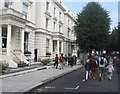
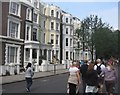
Walking towards the carnival
Pembridge Gardens.
Image: © Fernweh
Taken: 25 Aug 2013
0.07 miles
6
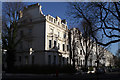
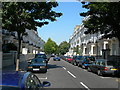
Pembridge Square
Housing along the north side of the square bathed in winter sunlight.
Image: © Martin Addison
Taken: 27 Jan 2012
0.07 miles
8

Old Boundary Marker by Pembridge Square, Paddington, Bayswater and Knightsbridge Parish
Parish Boundary Marker by the UC road, in parish of Paddington, Bayswater and Knightsbridge (City of Westminster District), Pembridge Square W2, East end of street, in pavement next to kerb by No 19 Pembridge Square, junction with Moscow Road.
Inscription reads:- : NO. 18. M.B.P. 1900 / IN THE CENTRE OF THE / TWO ROADS OPPOSITE IS THE / BOUNDARY OF PADDINGTON :
Surveyed
Milestone Society National ID: MX_PADDB25pb
Image: © Milestone Society
Taken: Unknown
0.08 miles
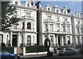
9
No.9 Dawson Place, Notting Hill
Most of the houses in this area are painted white to match.
Image: © David Anstiss
Taken: 14 Apr 2013
0.08 miles