IMAGES TAKEN NEAR TO
Poplar Place, LONDON, W2 4AS
Introduction
This page details the photographs taken nearby to Poplar Place, W2 4AS by members of the Geograph project.
The Geograph project started in 2005 with the aim of publishing, organising and preserving representative images for every square kilometre of Great Britain, Ireland and the Isle of Man.

There are currently over 7.5m images from over14,400 individuals and you can help contribute to the project by visiting https://www.geograph.org.uk
Image Map
Images are licensed for reuse under creativecommons.org/licenses/by-sa/2.0
Notes
- Clicking on the map will re-center to the selected point.
- The higher the marker number, the further away the image location is from the centre of the postcode.
Image Listing (323 Images Found)
Images are licensed for reuse under creativecommons.org/licenses/by-sa/2.0
Image
Details
Distance

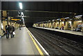
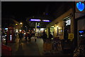
3
London, Queensway.
Opened by the Metropolitan Railway (MR) on 1st October 1868. Now part of the District & Circle Lines. Taken 22nd July 2015.
Image: © Andrew Riley
Taken: 22 Jul 2015
0.02 miles
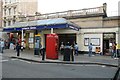
7
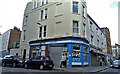
"The Athenian" grocery store
On Moscow Road, Bayswater
Image: © Neil Theasby
Taken: 10 Oct 2021
0.02 miles
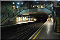
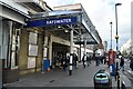
9
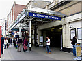
West London: Bayswater station
The white faience frontage by Charles Walter Clark,(architect to the Metropolitan Railway) incorporating the station name, can still be seen underneath the canopy.
Image: © Dr Neil Clifton
Taken: 29 May 2011
0.03 miles