IMAGES TAKEN NEAR TO
Westbourne Terrace, LONDON, W2 3UR
Introduction
This page details the photographs taken nearby to Westbourne Terrace, W2 3UR by members of the Geograph project.
The Geograph project started in 2005 with the aim of publishing, organising and preserving representative images for every square kilometre of Great Britain, Ireland and the Isle of Man.

There are currently over 7.5m images from over14,400 individuals and you can help contribute to the project by visiting https://www.geograph.org.uk
Image Map
Images are licensed for reuse under creativecommons.org/licenses/by-sa/2.0
Notes
- Clicking on the map will re-center to the selected point.
- The higher the marker number, the further away the image location is from the centre of the postcode.
Image Listing (1241 Images Found)
Images are licensed for reuse under creativecommons.org/licenses/by-sa/2.0
Image
Details
Distance
1
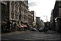
Sunset on the street
The Pride of Paddington Pub on the left and Eastbourne Terrace to the right, straight on for Bayswater.
Image: © roger geach
Taken: 28 Oct 2008
0.02 miles
3

2 Craven Road and 50 Eastbourne Terrace
Two smaller elements of a mass development of the west side of Eastbourne Terrace by C.H. Elsom & Partners, 1958-62.
The larger block looked empty at the time of the photo, and space to let was being advertised.
Image: © Stephen Richards
Taken: 3 Jul 2011
0.03 miles
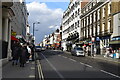
4
Praed Street W2
Looking into Craven Road. Paddington Station (overground / mainline) is to the right of the shot but not in view.
Image: © Danny P Robinson
Taken: 6 Aug 2006
0.03 miles
5
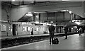
Paddington Underground Station
I do wonder how many tourists get confused by scenes like this, where the Metropolitan Railway proudly announces its apparent ownership of Paddington Station in Praed Street. In the meantime most of the commuters who use the station every working day will barely notice the carving in the pediment of the façade. The reason for the inscription is that in 1868 the Metropolitan Railway opened a new branch to South Kensington, with a new station at this location called Paddington (Praed Street). It was built in a cutting across the street to the south-east of Paddington mainline station. The station was renamed to simply "Paddington" in 1948 and now serves the Circle and District Lines, while the nearest Metropolitan Line station is Baker Street, three stops away on the Circle Line. The façade itself dates from a rebuilding in the 1920s.
Image: © Nigel Cox
Taken: 4 Dec 2007
0.03 miles
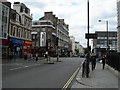
7
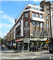
The Pride of Paddington
Pub with accommodation, located at the crossroads of Praed Street, Spring Street,
Craven Road and Eastbourne Terrace. Spring Street is ahead on the left.
Image: © Jaggery
Taken: 13 May 2012
0.03 miles
8
Praed Street entrance to Paddington underground station
See http://www.geograph.org.uk/photo/630289 for an account of the history of the building.
Image: © Jaggery
Taken: 12 May 2012
0.03 miles

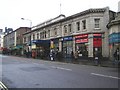
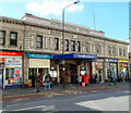
10

Shop on Craven Road, Paddington
The internet, newspapers, the lottery and any amount of tourist tat is available here at this small shop close to Paddington station.
Image: © Stephen McKay
Taken: 25 Jun 2009
0.04 miles